
Using GeoWebCache with OpenLayers, Google Maps and Virtual Earth
In this section will learn how to use GeoWebCache with OpenLayers, GoogleMaps and Virtual Earth through the simple examples.
GeoWebCache with OpenLayers
OpenLayers tiling the WMS request splitting it into several sub-requests sent to the geospatial server. To ensure that GeoWebCache returns tiles from the cache consistent with OpenLayers tiles, we should respect some constraints including:
- The tiles of the OpenLayers and GeoWebCache should have the same size in terms of pixels, both in terms of coverage area.
- The tiles of the OpenLayers and GeoWebCache should be aligned in the same grid.
Note
This ensures not only an optimal caching of tiles but also an optimal reuse of the GeoWebCache tiles with other clients as well as OpenLayers.
Create an wmts.html file and enter the following code:
<!DOCTYPE html>
  <html lang="en">
  <head>
    <meta charset="utf-8"/>
    <title>Counties of Colorado:EPSG:4326 image/png</title>
    <link rel="stylesheet" href="lib/ol3/css/ol.css" type="text/css">
    <!-- Use ol.js for production, and ol-debug.js for development
            script src="lib/ol3/ol.js" type="text/javascript"></script-->
    <script src="lib/ol3/ol-debug.js" type="text/javascript"></script>

                    <style>

    /* Map settings */
    #map {
       width: 600px;
       height: 400px;
    }
  </style>
</head>
<body>
  <div id="map" class="map"></div>

  <script>
      var projection = ol.proj.get('EPSG:4326');
      var projectionExtent = projection.getExtent();
      var mapExtent =  [-105.70160457542876, 39.799058451017345, -104.99644707392322, 40.301219114868005];
      var matrixIds = new Array(22);

      for (var z = 0; z < 22; ++z) {
        matrixIds[z] = "EPSG:4326:" + z;;
      }

      resolutions = [
            0.703125, 0.3515625, 0.17578125, 0.087890625,
            0.0439453125, 0.02197265625, 0.010986328125,
            0.0054931640625, 0.00274658203125, 0.001373291015625,
            6.866455078125E-4, 3.4332275390625E-4, 1.71661376953125E-4,
            8.58306884765625E-5, 4.291534423828125E-5, 2.1457672119140625E-5,
              1.0728836059570312E-5, 5.364418029785156E-6, 2.682209014892578E-6,
            1.341104507446289E-6, 6.705522537231445E-7, 3.3527612686157227E-7
      ];

      bouldersLayerWMTS = new ol.layer.Tile({
            source: new ol.source.WMTS({
            url: 'http://localhost:8083/geoserver/gwc/service/wmts',
              layer: 'boulder',
            matrixSet: 'EPSG:4326',
            format: 'image/png',
            projection: projection,
              tileGrid: new ol.tilegrid.WMTS({
                origin: ol.extent.getTopLeft(projectionExtent),
              resolutions: resolutions,
                matrixIds: matrixIds
              })
        })
    });

     var map = new ol.Map({
      layers: [bouldersLayerWMTS],
      target: 'map',
      view: new ol.View({
            extent: mapExtent,
            projection: projection,
            center: [-105.4, 40.03],
            zoom: 10
      })
    });

    </script>
  </body>
 </html>
Save the file in the Map folder located in:
Linux:
/opt/tomcat_geoserver/webapps/MapWindows:
%TRAINING_ROOT%/tomcat/instances/instance1/webapps/Map
Open the working map in your web browser at WMTS Page.
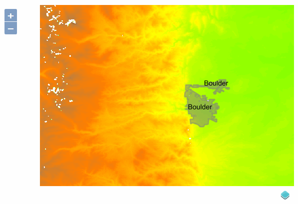
GeoWebCache with OpenLayers
Note
The default values are the following:
- Tile width: 256px
- Tile height: 256px
- Tile origin: EPSG:4326 -180,-90 ; EPSG:900913: -20037508.34,-20037508.34
- Resolution: EPSG:4326 180 / (2^k) ; EPSG:900913: (2*20037508.34)/(2^k), k represents the zoomlevel.
GeoWebCache with Google Maps
GeoWebCache also supports Google Maps client. An example of Google Maps client, which can be used as a base (template) for more complex client, is as follows:
- Create a new index.html file and enter the following code:
<html xmlns="http://www.w3.org/1999/xhtml">
        <head>
                <meta http-equiv="content-type" content="text/html; charset=utf-8"/>
                <title>Google Maps with GeoWebCache</title>
                <script src="https://maps.googleapis.com/maps/api/js?sensor=false" type="text/javascript"></script>
                <script type="text/javascript">
                        function initialize() {
                                var myOptions = {
                                          zoom: 9,
                                          center: new google.maps.LatLng(40, -105.5),
                                          zoomControl: true,
                                          mapTypeId: google.maps.MapTypeId.ROADMAP
                                        }
                                var map = new google.maps.Map(document.getElementById("map_canvas"), myOptions);

                                var countiesTiles = {
                                         getTileUrl: function(coord, zoom) {
                                           return "http://localhost:8083/geoserver/gwc/service/gmaps?layers=boulder&" +
                                                "zoom=" + zoom + "&x=" + coord.x + "&y=" + coord.y + "&format=image/png";
                                         },
                                         tileSize: new google.maps.Size(256, 256),
                                         isPng: true,
                                         opacity: 0.5
                                   };

                           var customMapType = new google.maps.ImageMapType(countiesTiles);
                           map.overlayMapTypes.insertAt(0, customMapType);

                        }
                </script>
                        </head>
        <body onload="initialize()" onunload="GUnload()">
           <div id="map_canvas" style="width: 596px; height: 367px"></div>
        </body>
</html>
Note
The
/service/gmapspath tells the dispatcher to use the gwcGmaps service for indexing and generating tiles compatible with this type of requests.
Save the file in the Map folder (same as previous section).
Open the working map in your web browser at Welcome Page.
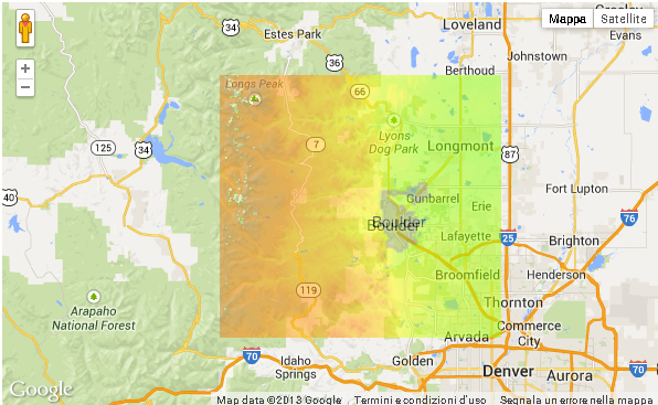
GeoWebCache with Google Maps
GeoWebCache with Virtual Earth
GeoWebCache can also support requests from MS Virtual Earth clients. An example of a client, which can be used as a base (template) for clients more complex; is the following:
Create a new index.html file and enter the following code:
<html xmlns="http://www.w3.org/1999/xhtml">
    <head>
            <title>Virtual Earth with GeoWebCache</title>
            <script type='text/javascript' src='http://www.bing.com/api/maps/mapcontrol'></script>
            <script type="text/javascript">
                     var map, tileLayer;
                     var tileLayerURL = 'http://localhost:8083/geoserver/gwc/service/ve?quadkey={quadkey}&format=image/png&layers=boulder';
             function GetMap(){
                             var map = new Microsoft.Maps.Map('#myMap', {
                                        credentials:'Your Bing Maps Key',
                                        center:new Microsoft.Maps.Location(40, -105.5),
                                        mapTypeId: Microsoft.Maps.MapTypeId.road,
                                        zoom: 9
                             });
                             var tileSourceSpec = new Microsoft.Maps.TileSource({
                                uriConstructor: tileLayerURL
                             });
                             var tileSourceLayer = new Microsoft.Maps.TileLayer({
                                title:'TITLE_OF_LAYER',
                                mercator: tileSourceSpec,
                                opacity: 0.5
                             });
                             map.layers.insert(tileSourceLayer);
                     }
            </script>
    </head>
    <body onload="GetMap();">
                  <div id='myMap' style="position:relative; width:596px; height:367px;"></div>
    </body>
</html>
Note
The
/service/vepath tells you to use the service gwcVEConverter for indexing and generating tiles compatible with this type of requests.Save the file in the Map folder replacing the created one in previous section.
Open the working map in your web browser at Welcome Page.
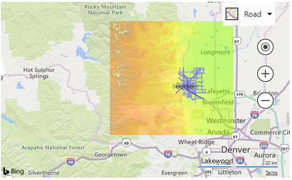
GeoWebCache with Virtual Earth