GeoServer implementation of ESRI Rest Services
This module introduces GeoServer support for the ESRI Rest Services.
GSR Extension
This plugin provides a GeoService REST compatibility API.
Installing the GSR Extension
To make GeoServer able to provide ESRI ReST Services it is necessary to install the GSR community module extension. Currently the plugin allows basic FeatureServer and MapServer functionality.
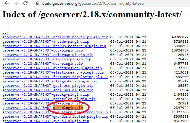
From the community page download the archive matching your GeoServer version.
https://build.geoserver.org/geoserver/2.18.x/community-latest/
Extract the JARs files from the downloaded ZIP archive:
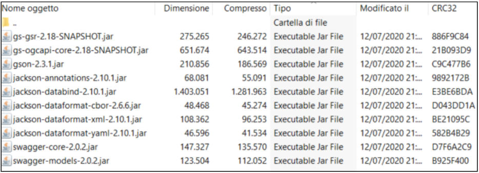
and copy them into the WEB-INF/lib folder of GeoServer.
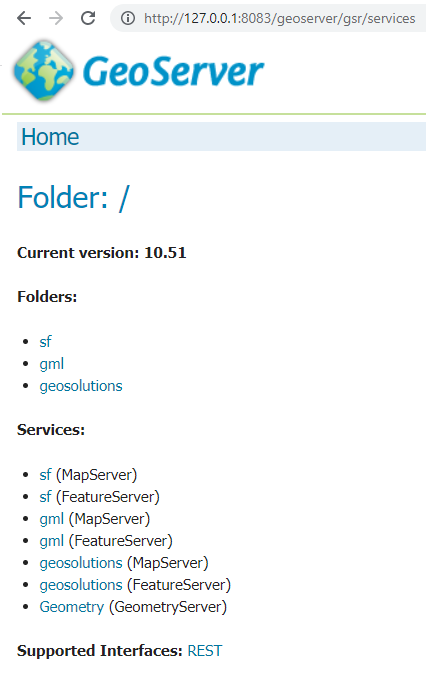
When the plugin is installed, in the welcome page of GeoServer we can see it in the Service Capabilities list:
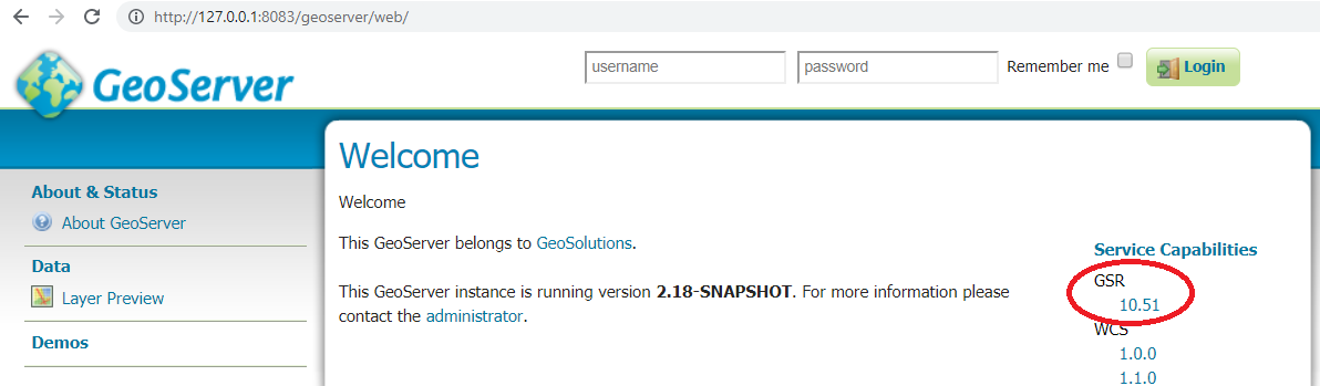
Clicking on the version of GSR (10.51 in the image above) we can see the list of the services available:
GSR Usage
The term ArcGIS service (in the API context) is equivalent to the GeoServer workspace.
URLs in GeoServer look like these:
http://localhost:8083/geoserver/gsr/services/<workspace>/MapServer/
http://localhost:8083/geoserver/gsr/services/<workspace>/FeatureServer/
A full list of functionalities supported is available here.
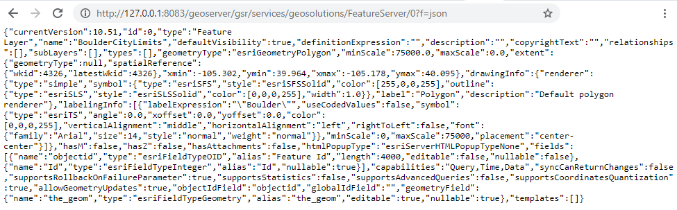
The GSR plugin allows, at the moment, to obtain data in json format:
http://localhost:8083/geoserver/gsr/services/geosolutions/FeatureServer/0?f=json
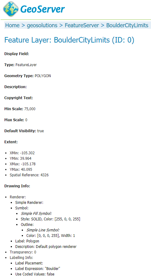
From the GeoServer web interface we can show details about the FeatureServer for a specific layer in html format:
http://localhost:8083/geoserver/gsr/services/geosolutions/FeatureServer/0
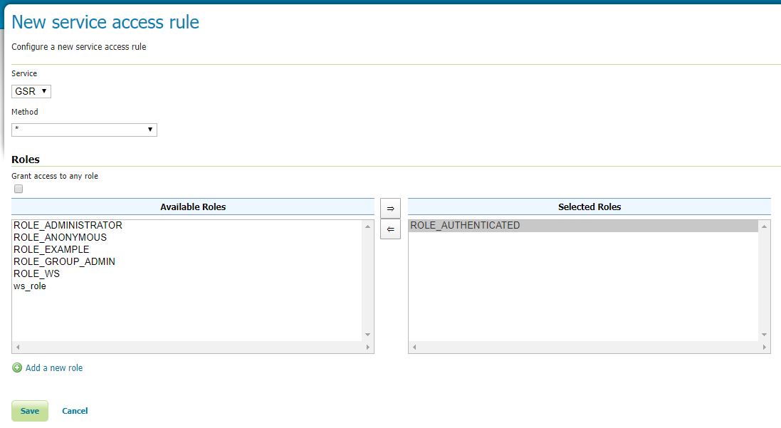
Acess rules
As with the other services, we can restrict access to specific GSR methods:
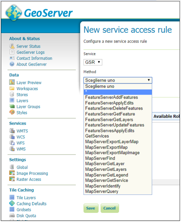
For example the following rule’s definition allows just authenticated users to use all methods from the GSR service.
Direct REST requests
In this section you will see the main ArcGIS REST requests.
To use the REST API, we need to know the well-known endpoint, which represents the server catalog.
For GeoServer, the default endpoint is as follows:
<protocol>://<host>:<port>/geoserver/gsr/services/<workspace>/<service>
- where:
- protocol: the protocol over which data is sent (http/https)
- host: geoserver host name or its IP address
- port: port number where GeoServer is listening
- workspace: name of the workspace of interest
- service: it represents the the name of the service type (e.g. FeatureServer)
Services Information
The following request shows the available services:
http://127.0.0.1:8083/geoserver/gsr/services?f=json{ "currentVersion": 10.51, "folders": ["sf", "gml", "geosolutions"], "services": [{ "name": "sf", "type": "MapServer" }, { "name": "sf", "type": "FeatureServer" }, { "name": "gml", "type": "MapServer" }, { "name": "gml", "type": "FeatureServer" }, { "name": "geosolutions", "type": "MapServer" }, { "name": "geosolutions", "type": "FeatureServer" }, { "name": "Geometry", "type": "GeometryServer" }] }
Services Information by workspace
The following request shows the services available for a specific workspace.
http://127.0.0.1:8083/geoserver/gsr/services/geosolutions?f=json{ "currentVersion": 10.51, "folders": [], "services": [{ "name": "geosolutions", "type": "MapServer" }, { "name": "geosolutions", "type": "FeatureServer" }] }
Feature Server information
http://127.0.0.1:8083/geoserver/gsr/services/geosolutions/FeatureServer?f=json{ "currentVersion": 10.51, "serviceDescription": "GeoSolutions GeoServer workshop WFS", "supportedQueryFormats": "JSON", "workspace": "geosolutions", "layers": [{ "id": 0, "name": "BoulderCityLimits" }, { "id": 1, "name": "Counties" }, { "id": 2, "name": "Mainrd" }, { "id": 3, "name": "Parcels" }, { "id": 4, "name": "Trails" }, ... ], "tables": [] }
Feature Layer information
http://127.0.0.1:8083/geoserver/gsr/services/geosolutions/FeatureServer/0?f=json{ "currentVersion": 10.51, "id": 0, "type": "Feature Layer", "name": "BoulderCityLimits", "defaultVisibility": true, "definitionExpression": "", "description": "", "copyrightText": "", "relationships": [], "subLayers": [], "types": [], "geometryType": "esriGeometryPolygon", "minScale": 75000.0, "maxScale": 0.0, "extent": { "geometryType": null, "spatialReference": { "wkid": 4326, "latestWkid": 4326 }, "xmin": -105.302, "ymin": 39.964, "xmax": -105.178, "ymax": 40.095 }, "drawingInfo": { "renderer": { "type": "simple", "symbol": { "type": "esriSFS", "style": "esriSFSSolid", "color": [255, 0, 0, 255], "outline": { "type": "esriSLS", "style": "esriSLSSolid", "color": [0, 0, 0, 255], "width": 1.0 } }, "label": "Polygon", "description": "Default polygon renderer" }, "labelingInfo": [{ "labelExpression": "\"Boulder\"", "useCodedValues": false, "symbol": { "type": "esriTS", "angle": 0.0, "xoffset": 0.0, "yoffset": 0.0, "color": [0, 0, 0, 255], "verticalAlignment": "middle", "horizontalAlignment": "left", "rightToLeft": false, "font": { "family": "Arial", "size": 14, "style": "normal", "weight": "normal" } }, "minScale": 0, "maxScale": 75000, "placement": "center-center" }] }, "hasM": false, "hasZ": false, "hasAttachments": false, "htmlPopupType": "esriServerHTMLPopupTypeNone", "fields": [{ "name": "objectid", "type": "esriFieldTypeOID", "alias": "Feature Id", "length": 4000, "editable": false, "nullable": false }, { "name": "Id", "type": "esriFieldTypeInteger", "alias": "Id", "nullable": true }], "capabilities": "Query,Time,Data", "syncCanReturnChanges": false, "supportsRollbackOnFailureParameter": true, "supportsStatistics": false, "supportsAdvancedQueries": false, "supportsCoordinatesQuantization": true, "allowGeometryUpdates": true, "objectIdField": "objectid", "globalIdField": "", "geometryField": { "name": "the_geom", "type": "esriFieldTypeGeometry", "alias": "the_geom", "editable": true, "nullable": true }, "templates": [] }
Feature Query IdsOnly
http://127.0.0.1:8083/geoserver/gsr/services/geosolutions/FeatureServer/0/query?f=json&returnIdsOnly=true&returnCountOnly=true{ "objectIdFieldName":"objectid", "objectIds":[1,2,3,4,5,6] }
Feature Query
http://127.0.0.1:8083/geoserver/gsr/services/geosolutions/FeatureServer/0/query?f=json&where=objectid=2{ "objectIdFieldName": "objectid", "globalIdFieldName": "", "geometryType": "esriGeometryPolygon", "spatialReference": { "wkid": 4326, "latestWkid": 4326 }, "fields": [{ "name": "Id", "type": "esriFieldTypeInteger", "alias": "Id", "nullable": true }, { "name": "objectid", "type": "esriFieldTypeOID", "alias": "objectid" }], "features": [{ "geometry": { "geometryType": "esriGeometryPolygon", "spatialReference": { "wkid": 4326, "latestWkid": 4326 }, "rings": [ [ [-105.24238159476572, 40.04050970882338], [-105.24289953484967, 40.040256934382334], [-105.24409153918523, 40.040260957205476], [-105.24408329439814, 40.04198114174503], [-105.24182246909132, 40.043853469213126], [-105.24107907521743, 40.04444544986711], [-105.23912655202311, 40.04598281682582], [-105.23906868003635, 40.04593807668883], [-105.2402817116495, 40.043965308973135], [-105.24060609629, 40.043431756793666], [-105.24238159476572, 40.04050970882338] ] ] }, "attributes": { "Id": 0, "objectid": 2 }, "id": "BoulderCityLimits.2" }] }
MapServer Information
http://127.0.0.1:8083/geoserver/gsr/services/geosolutions/MapServer?f=json{ "mapName": "FOSS4G 2011 styling examples", "layers": [{ "id": 0, "name": "13tde815295_200803_0x6000m_cl" }, { "id": 1, "name": "BoulderCityLimits" }, { "id": 2, "name": "Counties" }, { "id": 3, "name": "Mainrd" }, { "id": 4, "name": "Parcels" }, { "id": 5, "name": "Trails" }, ... ], "singleFusedMapCache": false, "capabilities": "Query", "spatialReference": { "wkid": 4326, "latestWkid": 4326 }, "workspace": "geosolutions" }
MapServer query using WHERE statement
This section explains how to use the query method with WHERE syntax.
http://127.0.0.1:8083/geoserver/gsr/services/geosolutions/MapServer/6/query?where=SOVEREIGNT='Netherlands'&f=json{ "objectIdFieldName": "objectid", "globalIdFieldName": "", "geometryType": "esriGeometryPolygon", "spatialReference": { "wkid": 4326, "latestWkid": 4326 }, "fields": [{ "name": "ScaleRank", "type": "esriFieldTypeInteger", "alias": "ScaleRank", "nullable": true }, { "name": "LabelRank", "type": "esriFieldTypeInteger", "alias": "LabelRank", "nullable": true }, { "name": "FeatureCla", "type": "esriFieldTypeString", "alias": "FeatureCla", "length": 50, "nullable": true }, { "name": "SOVEREIGNT", "type": "esriFieldTypeString", "alias": "SOVEREIGNT", "length": 32, "nullable": true }, ... ], "features": [{ "geometry": { "geometryType": "esriGeometryPolygon", "spatialReference": { "wkid": 4326, "latestWkid": 4326 }, "rings": [ [ [-69.89913876003575, 12.452005113164361], [-69.89567643907213, 12.42301463464861], [-69.94215938991869, 12.438517564336166], [-70.0041452704528, 12.500503444870262], [-70.06613115098688, 12.546986395716814], [-70.05086076524458, 12.597086696823766], [-70.03512529161179, 12.614114081263963], [-69.97313941107768, 12.56763113041741], [-69.91179948594723, 12.480478827357217], [-69.89913876003575, 12.452005113164361] ] ] }, "attributes": { "ADM0_DIF": 1.0, "GDP_MD_EST": 2258.0, "POSTAL": "AW", "GEOU_DIF": 0.0, "POP_EST": 103065.0, "ABBREV": "Aruba", "TERR_": "Neth.", "SOV_A3": "NL1", "GU_A3": "ABW", "LabelRank": 3, "ADM0_A3": "ABW", "ADMIN": "Aruba", "TYPE": "Country", "FIPS_10_": 0.0, "SOVEREIGNT": "Netherlands", ... }, "id": "WorldCountries.1" }, ... ] }
MapServer query using ENVELOPE statement
This section explains how to use the query method with an ENVELOPE filter.
http://127.0.0.1:8083/geoserver/gsr/services/geosolutions/MapServer/0/query?geometry=-105.27,40.07,-105.25,40.08&geometryType=esriGeometryEnvelope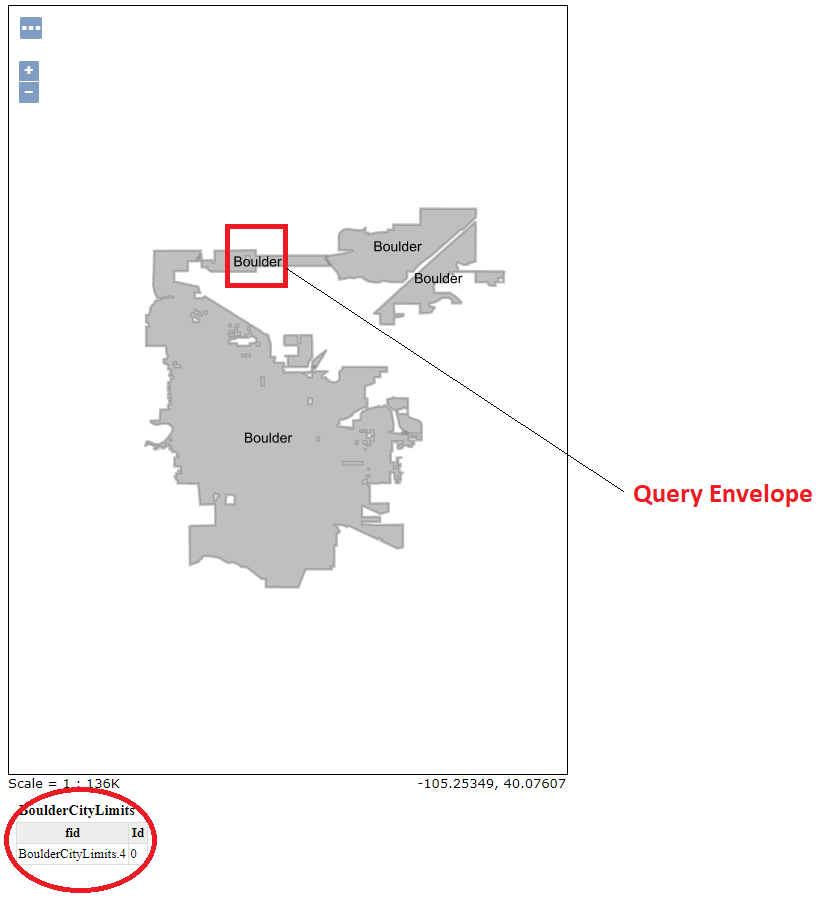
{
   "objectIdFieldName": "objectid",
   "globalIdFieldName": "",
   "geometryType": "esriGeometryPolygon",
   "spatialReference": {
      "wkid": 4326,
      "latestWkid": 4326
   },
   "fields": [{
      "name": "Id",
      "type": "esriFieldTypeInteger",
      "alias": "Id",
      "nullable": true
   }, {
      "name": "objectid",
      "type": "esriFieldTypeOID",
      "alias": "objectid"
   }],
   "features": [{
      "geometry": {
         "geometryType": "esriGeometryPolygon",
         "spatialReference": {
            "wkid": 4326,
            "latestWkid": 4326
         },
         "rings": [
            [
               [-105.26349223715587, 40.08020079753432],
               [-105.26346508409019, 40.07824343333578],
               ...
            ],
            [
               [-105.2656227396715, 40.07613576631772],
               [-105.2656319850513, 40.07746812505805],
               ...
            ]
         ]
      },
      "attributes": {
         "Id": 0,
         "objectid": 4
      },
      "id": "BoulderCityLimits.4"
   }]
}
Consuming data from ArcGIS Javascript API
In this section you will see some examples of how to consume GeoServer Rest services from ArcGIS Javascript API.
Documentation about this API is available here.
FeatureLayer
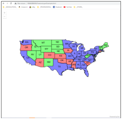
The following example uses the ArcGIS Javascript API to access GeoServer Rest service as FeatureServer:
<html>
   <head>
      <meta charset="utf-8">
      <meta name="viewport" content="initial-scale=1,maximum-scale=1,user-scalable=no">
      <title>FeatureLayer - 4.5</title>
      <link rel="stylesheet" href="https://js.arcgis.com/4.11/esri/css/main.css">
      <script src="https://js.arcgis.com/4.11/"></script>
      <style>
         html,
         body,
         #viewDiv {
               padding: 0;
               margin: 0;
               height: 100%;
               width: 100%;
         }
      </style>
      <script>
         require([
                  "esri/Map",
                  "esri/views/MapView",
                  "esri/layers/FeatureLayer",
                  "dojo/domReady!layers-featurelayer"
               ],
               function (Map, MapView,
                        FeatureLayer) {
                  var map = new Map({});
                  var view = new MapView({
                     container: "viewDiv",
                     map: map,
                     extent: { // autocasts as new Extent()
                           xmin: -107.97,
                           ymin: 25.46,
                           xmax: -91.28,
                           ymax: 37.74,
                           spatialReference: 4326
                     }
                  });
                  /********************
                  * Add feature layer
                  ********************/
                  var featureLayer2 = new FeatureLayer({
                  url: "http://127.0.0.1:8083/geoserver/gsr/services/geosolutions/FeatureServer/17",
                  outFields: ["*"]
               });
               map.add(featureLayer2);
         });
         require(["esri/config"], function (esriConfig) {
            esriConfig.request.corsEnabledServers.push("localhost:8083");
         });
      </script>
   </head>
   <body>
      <div id="viewDiv"></div>
   </body>
</html>
Deploying the page in a web server and opening the page in a browser we can see the following Web GIS page and interact with the map:
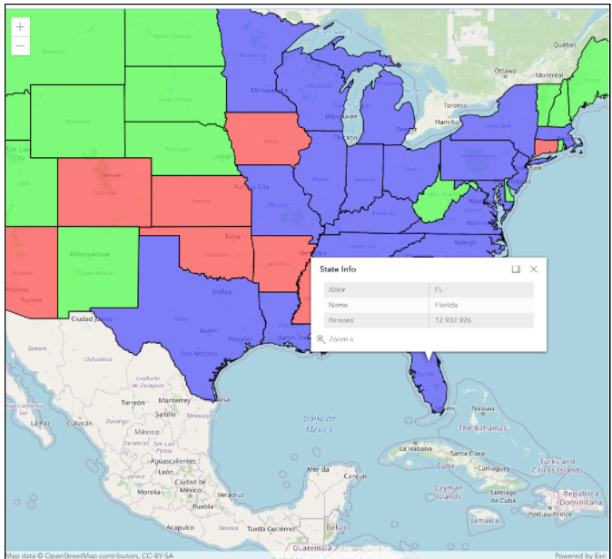
FeatureTable
The following example uses the ArcGIS Javascript API to access GeoServer Rest service as FeatureServer and display information in a popup when the user click an object in the map:
<html>
<head>
   <meta charset="utf-8">
   <meta name="viewport" content="initial-scale=1,maximum-scale=1,user-scalable=no">
   <title>Intro to PopupTemplate - 4.8</title>
   <style>
      html,
      body,
      #viewDiv {
         padding: 0;
         margin: 0;
         height: 100%;
         width: 100%;
      }
   </style>
   <link rel="stylesheet" href="https://js.arcgis.com/4.8/esri/css/main.css">
   <script src="https://js.arcgis.com/4.8/"></script>
   <script>
      require([
         "esri/Map",
         "esri/layers/FeatureLayer",
         "esri/views/MapView",
         "dojo/domReady!"
      ], function(
         Map,
         FeatureLayer,
         MapView
      ) {
         // Create the map
         var map = new Map({
         basemap: "osm"
         });
         // Create the MapView
         var view = new MapView({
         container: "viewDiv",
         map: map,
         extent: {
               xmin: -74.255591362951,
               ymin: 40.4961153956091,
               xmax: -73.7000090634675,
               ymax: 40.915532775817,
               spatialReference: 4326
         },
         });
         var template = {
         title: "State Info",
         content: [{
            type: "fields",
            fieldInfos: [{
               fieldName: "STATE_ABBR",
               label: "Abbr",
               visible: true
            }, {
               fieldName: "STATE_NAME",
               label: "Name",
               visible: true
            }, {
               fieldName: "PERSONS",
               label: "Persons",
               visible: true,
               format: {
               digitSeparator: true,
               places: 0
               }
            }]
         }]
         };
         var featureLayer = new FeatureLayer({
         url: "http://localhost:8083/geoserver/gsr/services/geosolutions/FeatureServer/17",
         outFields: ["*"],
         popupTemplate: template
         });
         map.add(featureLayer);
      });
      require(["esri/config"], function (esriConfig) {
               esriConfig.request.corsEnabledServers.push("localhost:8083");
         });
   </script>
</head>
<body>
   <div id="viewDiv"></div>
</body>
</html>
Deploying the page in a web server and opening the page in a browser we can see the following Web GIS page and interact with the map: