WCS and WMS requests on Dimensions with Ranges
In this section, we will introduce how to deal with coverages having ranged dimensions, in terms of WMS and WCS requests. A coverage having dimensions with ranges has data slices which are valid within an interval (as an instance a temporal interval or an altitude/depth interval). Let’s take a look to a couple of water temperature sample datasets.
The folder %TRAINING_ROOT%/geoserver_data/coverages/time_domainsRanges contains an example of a dataset with ranged Dimensions.
Each granule name is composed by several parts; examine two granules:
temp_020_099_20081101T000000_20081104T000000.tiff
temp_100_150_20081105T000000_20081107T000000.tiff
The same parts contains ranges of values
- 020_099 / 100_150
- 20081101T000000_20081104T000000 / 20081105T000000_20081107T000000
Each couple of values represents the start and the end values of a specific Dimension reported in the indexer.properties
The indexer.properties contains the following information:
TimeAttribute=time;endtime
ElevationAttribute=lowz;highz
Schema=the_geom:Polygon,location:String,time:java.util.Date,endtime:java.util.Date,lowz:Integer,highz:Integer
PropertyCollectors=TimestampFileNameExtractorSPI[timeregex](time),TimestampFileNameExtractorSPI[timeregexend](endtime),IntegerFileNameExtractorSPI[elevationregex](lowz),IntegerFileNameExtractorSPI[elevationregexhigh](highz)
- TimeAttribute=time;endtime - specifies the attributes names for the time dimension.
- ElevationAttribute=lowz;highz - specifies the attributes names for the elevation dimension.
- Schema=the_geom:Polygon,location:String,time:java.util.Date,endtime:java.util.Date,lowz:Integer,highz:Integer - describes the schema on the DB and the attributes types.
- PropertyCollectors=TimestampFileNameExtractorSPI[timeregex](time),TimestampFileNameExtractorSPI[timeregexend](endtime),IntegerFileNameExtractorSPI[elevationregex](lowz),IntegerFileNameExtractorSPI[elevationregexhigh](highz) - associates a regex name extractor to each attribute value.
Looking at the layer configuration, GeoServer automatically recognizes the available Dimensions. Setting the Continuous interval on time and elevation, the ImageMosaic Plugin will read automatically the ranges using the data structure.
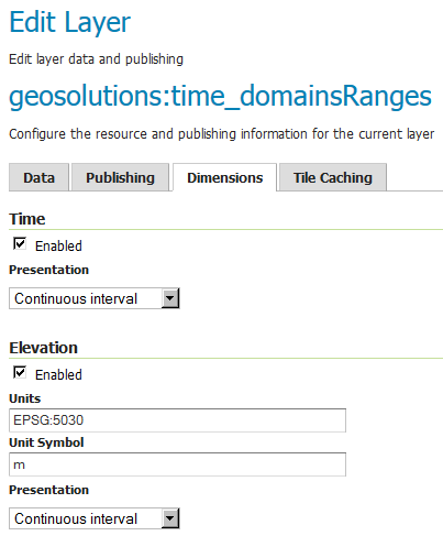
Take a look also to the WMS GetCapabilities and notice how time and elevation are represented as continuos intervals; notice how the ranges are automatically detected.
http://localhost:8083/geoserver/ows?service=wms&version=1.3.0&request=GetCapabilities
<Layer queryable="1">
  <Name>geosolutions:time_domainsRanges</Name>
  <Title>time_domainsRanges</Title>
  <Abstract/>
  <KeywordList>
    <Keyword>WCS</Keyword>
    <Keyword>ImageMosaic</Keyword>
    <Keyword>time_domainsRanges</Keyword>
  </KeywordList>
  <CRS>EPSG:4326</CRS>
  <CRS>CRS:84</CRS>
  <EX_GeographicBoundingBox>
    <westBoundLongitude>0.2372206885127698</westBoundLongitude>
    <eastBoundLongitude>14.592757149389236</eastBoundLongitude>
    <southBoundLatitude>40.562080748421806</southBoundLatitude>
    <northBoundLatitude>44.55808294568743</northBoundLatitude>
  </EX_GeographicBoundingBox>
  <BoundingBox CRS="CRS:84" minx="0.2372206885127698" miny="40.562080748421806" maxx="14.592757149389236" maxy="44.55808294568743"/>
  <BoundingBox CRS="EPSG:4326" minx="40.562080748421806" miny="0.2372206885127698" maxx="44.55808294568743" maxy="14.592757149389236"/>
  <Dimension name="time" default="current" units="ISO8601">
  2008-11-01T00:00:00.000Z/2008-11-07T00:00:00.000Z/PT1S
  </Dimension>
  <Dimension name="elevation" default="20.0" units="EPSG:5030" unitSymbol="m">20.0/150.0/0</Dimension>
WMS Sample Requests
GetMap
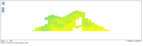
http://localhost:8083/geoserver/geosolutions/wms?service=WMS&version=1.1.0&request=GetMap&layers=geosolutions:time_domainsRanges&styles=temp&bbox=0.2372206885127698,40.562080748421806,14.592757149389236,44.55808294568743&width=1185&height=330&srs=EPSG:4326&format=application/openlayers&time=2008-11-01T00:00:00.000Z
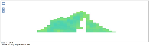
http://localhost:8083/geoserver/geosolutions/wms?service=WMS&version=1.1.0&request=GetMap&layers=geosolutions:time_domainsRanges&styles=temp&bbox=0.2372206885127698,40.562080748421806,14.592757149389236,44.55808294568743&width=1185&height=330&srs=EPSG:4326&format=application/openlayers&time=2008-11-07T00:00:00.000Z
WCS 2.0 Sample Requests
DescribeCoverage
KVP Encoding
Single Coverage
http://localhost:8083/geoserver/ows?service=WCS&version=2.0.1&request=DescribeCoverage&coverageId=geosolutions__time_domainsRanges
The request will download an XML containing the details of the multidimensional coverage. Notice the dimensions ranges of validity expressed in the XML document.
The TimeDomain reports the list of the available TimePosition‘s
<wcsgs:TimeDomain default="2008-11-07T00:00:00.000Z">
        <gml:TimePeriod gml:id="geosolutions__time_domainsRanges_tp_0">
                <gml:beginPosition>2008-10-01T00:00:00.000Z</gml:beginPosition>
                <gml:endPosition>2008-11-07T00:00:00.000Z</gml:endPosition>
        </gml:TimePeriod>
</wcsgs:TimeDomain>
The ElevationDomanin reports the list values for the available elevations
<wcsgs:ElevationDomain uom="m" default="20.0">
        <wcsgs:Range>
                <wcsgs:start>20.0</wcsgs:start>
                <wcsgs:end>150.0</wcsgs:end>
        </wcsgs:Range>
</wcsgs:ElevationDomain>
GetCoverage
KVP Encoding
The following request will get back a GeoTiff produced on top of raw data defined by this selection:
- Trimming on latitude [40 -> 50]
- Trimming on longitude [5 -> 20]
- Slicing on elevation [20]
- Slicing on time [2008-11-04T00:00:00.000Z]
GetCoverage request using KVP encoding
http://localhost:8083/geoserver/wcs?request=GetCoverage&service=WCS&version=2.0.1&coverageId=geosolutions__time_domainsRanges&Format=geotiff&subset=http://www.opengis.net/def/axis/OGC/0/Long(5,20)&subset=http://www.opengis.net/def/axis/OGC/0/Lat(40,50)&subset=http://www.opengis.net/def/axis/OGC/0/elevation(20)&subset=http://www.opengis.net/def/axis/OGC/0/time("2008-11-04T00:00:00.000Z")
The browser should download a geosolutions__time_domainsRanges.tif containing the requested data.
As explained in the previous chapter, trimming on dimensions is only supported when the output format properly supports the creation of a dataset containing multiple results. Notice however that specifying a value of time or elevation inside the range will always return back data. In this case you don’t have to specify the exact time position or elevation value.
Try for instance something like
- Trimming on latitude [40 -> 50]
- Trimming on longitude [5 -> 20]
- Slicing on elevation [20.5]
- Slicing on time [2008-11-01T00:15:00.000Z]
http://localhost:8083/geoserver/wcs?request=GetCoverage&service=WCS&version=2.0.1&coverageId=geosolutions__time_domainsRanges&Format=geotiff&subset=http://www.opengis.net/def/axis/OGC/0/Long(5,20)&subset=http://www.opengis.net/def/axis/OGC/0/Lat(40,50)&subset=http://www.opengis.net/def/axis/OGC/0/elevation(20.5)&subset=http://www.opengis.net/def/axis/OGC/0/time("2008-11-01T00:15:00.000Z")
As explained in the NetCDF output Format for WCS 2.0.1 requests, a NetCDF output format has been developed to write down a NetCDF file with the proper contents coming from a multidimensional output request. Lets do a GetCoverage request involving trimming on these dimensions: latitude, longitude, elevation and time, by specifying these ranges of values:
- Trimming on latitude [40 -> 50]
- Trimming on longitude [5 -> 20]
- Trimming on elevation [20 -> 150]
- Trimming on time [2008-11-01T00:00:00.000Z -> 2008-11-07T00:00:00.000Z]
GetCoverage request using KVP encoding
- Paste the following link on the browser to send a getCoverage request asking for a NetCDF output containing the granules for the specified dimensions.
http://localhost:8083/geoserver/wcs?request=GetCoverage&service=WCS&version=2.0.1&coverageId=geosolutions__time_domainsRanges&Format=application/x-netcdf&subset=http://www.opengis.net/def/axis/OGC/0/Long(5,20)&subset=http://www.opengis.net/def/axis/OGC/0/Lat(40,50)&subset=http://www.opengis.net/def/axis/OGC/0/elevation(20,150)&subset=http://www.opengis.net/def/axis/OGC/0/time("2008-11-01T00:00:00.000Z","2008-11-07T00:00:00.000Z")
The browser should download a geosolutions__time_domainsRanges.nc containing the requested data.
Seeing results on Panoply
Once the file has been saved to disk, navigate to the %TRAINING_ROOT%/Panoply.bat file and run it.
Open the newly downloaded
geosolutions__time_domainsRanges.ncon Panoply.Double click on the time_domainRanges dataset and push on the lon-lat button.
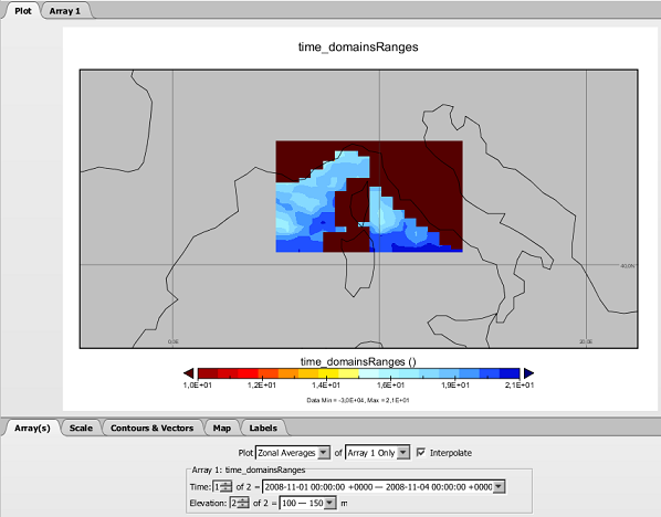
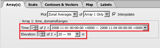
You will see a map rendering the layer for a specific set of Time, Elevation, as reported in the bottom section of the interface. This time, the Time and Elevation dimensions will show range values.
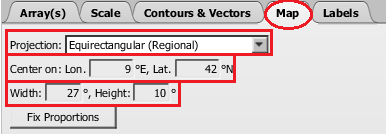
As you can see, the image is really small so we can center it on the window. Switch to the Map tab and change the Projection from the drop down list switching from Equirectangular to Equirectangular (Regional). Then adjust the region to see a bigger image by setting these values in the proper text boxes:
- Center on Lon = 9
- Lat = 42
- Width = 27
- Height = 10
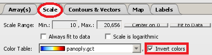
Switch to the Scale tab and change the Scale Range Min to 10 and set Invert colors
Now, you can switch back to the Array(s) tab which also allows you to change the values of each dimension to see the related data.