
ImageMosaic file indexing options
As introduced in the previous section, the set of dimensions available for the mosaic, the schema of the index, as well as the way to retrieve the values of the dimension values may be specified by properly configuring a set of auxiliary files composing the mosaic indexer.
While improving the support for coverage stores dealing with multiple coverages and multiple dimensions, a new indexer (XML based) has been developed: it will be introduced at the end of this chapter.
Note
In case the user was interested, the ImageMosaic plugin uses internally a GeoTools DataStore to interact with the granule’s index regardless of whether it is stored inside a DBMS or a Shapefile. The datastore.properties file is nothing more than the representation on disk of the configuration parameters that a GeoTools DataStore can be provided with to connect to a vector store. This will be introduced in the next section.
ImageMosaic indexer
The imageMosaic indexer specifies the schema of the underlying GeoTools DataStore storing the granule’s index, as well as the name of the time/elevation/custom attributes (if any), the type of the attributes and the configuration params. Whenever a time/elevation/custom attribute is defined, a sidecar file is required specifying how that attribute should be populated. All the configuration files must be placed in the root of the mosaic directory.
indexer.properties
| Parameter | Mandatory | Description |
| TimeAttribute | N | Specifies the name of the time-variant attribute. |
| ElevationAttribute | N | Specifies the name of the elevation attribute. |
| Schema | Y | A comma separated sequence that describes the mapping between attribute and the data type. |
| PropertyCollectors | Y | Specifies the extractor classes. |
| Mosaic_Configuration_Param | N | Specific mosaic configuration params (see below) |
Important
TimeAttribute and ElavationAttribute are not mandatory params.
The following block represents an example of indexer.properties file which will be used in the next section of this training to configure some meteo datasets.
TimeAttribute=ingestion
ElevationAttribute=elevation
Schema=*the_geom:Polygon,location:String,ingestion:java.util.Date,elevation:Double
PropertyCollectors=TimestampFileNameExtractorSPI[timeregex](ingestion),DoubleFileNameExtractorSPI[elevationregex](elevation)
Caching=false
AbsolutePath=false
- The PropertyCollectors section defines the extractor classes which are delegate to populate a specific attribute (reported between round brackets ( )). The value between square brackets [ ] represents the file name (without the mandatory .properties suffix) containing the regular expression needed to extract the attribute value from the file name. The instance of the property collector also indicates the type of object computed by the specific collector, so a TimestampFileNameExtractorSPI will return Timestamps whilst a DoubleFileNameExtractorSPI will return Double numbers.
- The last 2 parameters (Caching and AbsolutePath) are Mosaic configuration parameters. They will be introduced afterwards in the ImageMosaic Parameters subsection.
Property collectors
The following table enumerates the available property collectors
| Collector SPI name | Description |
|---|---|
| ByteFileNameExtractorSPI DoubleFileNameExtractorSPI FloatFileNameExtractorSPI IntegerFileNameExtractorSPI LongFileNameExtractorSPI ShortFileNameExtractorSPI | Extracts an number from the file name using a regular expression specified in a sidecar file, casting it to the desired type based on the SPI name (e..g, DoubleFileNameExtractorSPI extracts double precision floating points, IntegerFileNameExtractorSPI extracts 32 bit integers) |
| TimestampFileNameExtractorSPI | Extracts a timestamp from the filename using a regular expression specified in a sidecar file |
| StringFileNameExtractorSPI | Extracts a string from the filename using a regular expression specified in a sidecar file |
| CurrentDateExtractorSPI | Returns the current date and time (useful to track ingestion times in a mosaic) |
| FSDateExtractorSPI | Returns the creation date of the file being harvested |
| DateExtractorSPI | Returns the date found in tiff file header “DateTime” (code 306) |
| ResolutionExtractorSPI ResolutionXExtractorSPI ResolutionYExtractorSPI | Returns the native resolution of the raster being harvested. ResolutionExtractorSPI and ResolutionXExtractorSPI return the x resolution of the raster, ResolutionYExtractorSPI returns the resolution on the Y axis instead |
| CRSExtractorSPI | Returns the code of the the raster coordinate reference system, as a string, e.g. “EPSG:4326” |
The above indexer.properties example refers a TimestampFileNameExtractorSPI to populate a time dimension based on a timeregex.properties file. Let’s have a look at that.
timeregex.properties
| Parameter | Mandatory | Description |
| regex | Y | Specifies the pattern used for extracting the time information from the file. |
| format | N | When date and time in the filename aren’t following the ISO8601 specification, you can specify a custom format syntax. See below |
| useHighTime | N | Used when parsing reduced precision datetime (i.e. missing the minutes or seconds part) to use the higher time of the missing component, included in that reduced value. See below for a practical example. |
| fullPath | N | Used when the datetime isn’t self contained in the filename but the temporal components are spread on the full file path. See below. |
The following block represents an example of indexer.properties file which will be used in the next section of this training to configure some meteo datasets.
regex=[0-9]{8}T[0-9]{9}Z(\?!.\*[0-9]{8}T[0-9]{9}Z.\*)
Some examples of usage of the optional parameters:
format
regex=.*([0-9]{10}).*,format=yyyyMMddHH
useHighTime
regex=.*([0-9]{10}).*,format=yyyyMMddHH,useHighTime=true
fullPath
regex=(?:/)(\d{8})(?:/)(?:Temperature.)(T\d{4})(?:.tif),fullPath=true
elevationregex.properties
| Parameter | Mandatory | Description |
| regex | Y | Specifies the pattern used for extracting the elevation information from the file. |
The following block represents an example of indexer.properties file which will be used in the next section of this training to configure some meteo datasets.
regex=(?<=_)(\\d{4}\\.\\d{3})(?=_)
ImageMosaic indexer.properties parameters
- AuxiliaryFile: path to an auxiliaryFile to be used for internal purposes (As an instance, when dealing with NetCDF granules, it refers to the NetCDF XML Ancillary file). It will introduced in the next sections.
- AbsolutePath: A boolean flag stating whether the granules paths to be saved within the location attribute of the index should be absolute paths or relative ones.
- Caching: A boolean flag to disable/enable caching. When enabled the ImageMosaic will try to pin in memory the entire content of the index to reduce loading/query time. If we have a large granule index and/or we want to ingest in real time new granules (e.g. the index is on a database and we interact directly with it) we need to disable caching, otherwise we can enable it.
- CanBeEmpty: A boolean flag used for configuring empty mosaics. When enabled the ImageMosaic will not throw an exception caused by the absence of any coverage. By default it is set to false. It’s useful to create an ImageMosaic via REST by first sending the configuration and configuring the store and finally harvest data to populate it.
- Envelope2D: An imposed envelope (LLX, LLY ULX, ULY). It overrides any envelope information contained within the granules.
- ExpandToRGB: A boolean flag to force (if set to true) color expansion from index color model (paletted datasets) to component color model (RGB).
- IndexingDirectories: Comma separated values list of paths referring to directories containing granules to be indexed. If unspecified, the IndexingDirectory will be the mosaic configuration dir. This parameter allows to configure a mosaic on a folder which contains configuration files only whilst the real granules to be indexed are stored somewhere else.
- Name: The name to be assigned to the index. If unspecified, the index name will usually match the name of the folder containing the mosaic.
- Recursive: A boolean flag used at indexing time. When set the true, the indexer will look for granules by scanning any subdirectory contained in the indexing directory. If false, only the main folder will be analyzed. (Default value is “true”).
- UseExistingSchema: A boolean flag used for enabling/disabling the use of existing schemas. When enabled the ImageMosaic will start indexing granules using the existing database schema (from datastore.properties) instead of populating it. It is useful when you already have a database with a valid mosaic schema (the_geom, location and other attributes, f.e. take a look at gdalindex) or when you do not want to rename the images to add times and dimensions (you should simply add them to the table, to AdditionalDomainAttributes and to PropertyCollectors). By default it is set to false.
- Wildcard: Wildcard used to specify which files should be scan by the indexer (As an instance: “.”).
- NoData: Specifies the NoData for the mosaic. This might be useful, as an instance, when imposing the Envelope2D. During image mosaic initialization, a small 5x5 pixels sample read is performed by ImageMosaic on the Envelope’s corner in order to retrieve granule’s metadata and properties, as nodata. If Envelope2D is forced in configuration, there might be the case that this sample read will not involve any actual granule so a default noData will be set which may be different with respect to what is actually stored on granules. Specifying the desired NoData property in the indexer will solve this type of issue.
- WrapStore: By default, PostgreSQL identifiers can’t be longer than 63 chars. Longer names will be truncated to that fixed length. When dealing with multidimensional datasets (for instance: NetCDFs, GRIBs) each variable (NetCDF) or parameter (GRIB) is indexed into a table with the same name. Therefore an
atmosphere-absorption-optical-thickness-due-to-particulate-organic-matter-ambient-aerosol-particlesNetCDF CF variable will be associated to a table with the same name. PostgreSQL will truncate that toatmosphere-absorption-optical-thickness-due-to-particulate-orgabreaking the one-to-one mapping and therefore breaking the proper functioning. Setting the WrapStore flag totruewill establish a hidden mapping between full long names and truncated table names to support proper working. - MosaicCRS: The “native” CRS of the mosaic, that is, the one in which footprints are collected. Useful when dealing with granules in multiple CRSs (see tutorial).
Next step is focusing on the new indexer structure which has been developed in order to regroup most part of the information within a single XML file.
ImageMosaic indexer(XML) schema
The schema definition of the new XML indexer is depicted in the following picture:
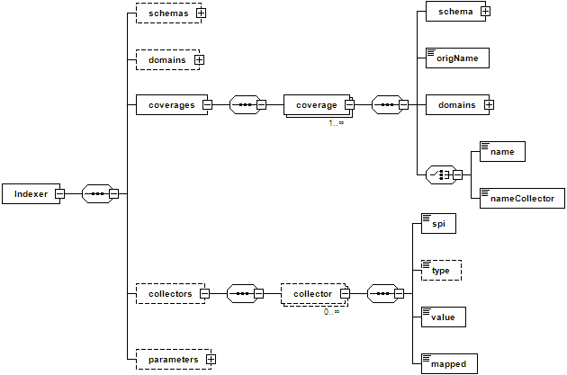
ImageMosaic indexer schema
The elements of the index are:
- schemas: an optional complex type made of a sequence of 0 or more schema objects.
- schema: is composed of:
- a name and a ref optional attributes.
- an attributes element listing the attribute+types composing the DB schema (As an instance: the_geom:Polygon,coverage:String,imageindex:Integer).
The schemas are used to define the attributes composing the index of the mosaic catalog.
- domains: an optional complex type element describing the domains defining the coverages, which are represented by 1 or more domain objects.
- domain: A complex type made of:
a name and a ref attributes.
- a complex type attributes made of 1 or more attribute elements.
- attribute: a name and a collectorRef attributes where the collectorRef may reference to a collector element which will be used to populate the value for that attribute.
The domains define the dimensions composing the coverage’s domain. (note that latitude/longitude X/Y aren’t part of the domains definition since they are the minimal dimensions to define a coverage). The attribute elements define the attribute of the schema containing the values for that domain.
- coverages: a complex type made of a sequence of 1 or more coverage objects.
- coverage: is composed of:
- a schema object defining the schema for that coverage. The schema may be a fully defined schema (by its name and the attributes element being filled) or a reference to a schema defined in the schemas node, through the ref attribute specification.
- OrigName: may be used to indicate the name of the underlying original variable name (GOME2 data has each variable named “z”).
- one of name/nameCollector elements: where name specifies the coverage name WHILST nameCollector refers to a Collector element which will be used to determine the coverage name.
The coverages sequence defines the coverages composing the store referred by this indexer. Coverage names which aren’t listed on this section will be skipped.
- collectors: a complex type made of a sequence of 1 or more collector object.
- collector: is composed of:
- an spi element defining the SPI class name to instantiate the proper PropertyCollector.
- an optional type element defining the type of property it will handle (for future usage).
- a value element defining the mapping rule. As an instance, in case of regular expression mapping based property collector, it should contain the regex directly.
- a mapped element defining the name of the attribute or property it’s mapped to (for backward mapping if needed).
Collectors allow to define rules (as an instance regular expressions) to collect a property/value to be assigned to an attribute from an information source. Common use cases are, as an instance, retrieving information like a time value from the name of the files representing a granule.
- parameters: an optional complex type made of parameter objects.
- parameter: an element made of:
- a name attribute.
- a value element.
Parameters allow to customize the ImageMosaic behaviour and configuration. The list of supported parameters and their meaning has been already illustrated.
ImageMosaic XML indexer example
Navigate to the workshop directory
%TRAINING_ROOT%/geoserver_data/coverages/polyphemus/indexer.xmland open it in a text editor. You will see the content of the new XML indexer definition.<?xml version="1.0" encoding="UTF-8" standalone="yes"?> <Indexer> <domains> <domain name="time"> <attributes><attribute>time</attribute></attributes> </domain> <domain name="elevation"> <attributes><attribute>elevation</attribute></attributes> </domain> <domain name="fileDate"> <attributes><attribute ref="fileDateCollector">fileDate</attribute></attributes> </domain> <domain name="updated"> <attributes><attribute ref="updatedCollector">updated</attribute></attributes> </domain> </domains> <schemas> <schema name="default"> <attributes>the_geom:Polygon,location:String,imageindex:Integer,time:java.util.Date,elevation:Double,fileDate:java.util.Date,updated:java.util.Date</attributes> </schema> </schemas> <coverages> <coverage> <name>V</name> <schema ref="default"></schema> <domains> <domain ref="time" /> <domain ref="elevation" /> <domain ref="fileDate" /> <domain ref="updated" /> </domains> </coverage> <coverage> <name>O3</name> <schema ref="default" /> <domains> <domain ref="time" /> <domain ref="elevation" /> <domain ref="fileDate" /> <domain ref="updated" /> </domains> </coverage> <coverage> <name>NO2</name> <schema ref="default" /> <domains> <domain ref="time" /> <domain ref="elevation" /> <domain ref="fileDate" /> <domain ref="updated" /> </domains> </coverage> </coverages> <collectors> <collector name="fileDateCollector"> <value>[0-9]{8}</value> <spi>TimestampFileNameExtractorSPI</spi> <mapped>fileDate</mapped> </collector> <collector name="updatedCollector"> <value>MODIFY_TIME</value> <spi>RuntimeExtractorSPI</spi> <mapped>updated</mapped> </collector> </collectors> <parameters> <parameter name="AuxiliaryFile" value="polyphemus-test.xml" /> <parameter name="AbsolutePath" value="true" /> </parameters> </Indexer>
This represents a sample XML indexer used to configure an ImageMosaic for polyphemus data.
The next section will provide more details on the datastore.properties definition.