
Introduction to OGC
From the OGC home page :
The OGC (Open Geospatial Consortium) is an international not for profit organization committed to making quality open standards for the global geospatial community. These standards are made through a consensus process and are freely available for anyone to use to improve sharing of the world’s geospatial data.
OGC provides standard for both data and protocols to exchange it.
Data standards
Some example of standards at the data level include:
- GML (Geographic Markup Language), a XML dialect used to exchange both vector and raster data.
- KML (Keyhole Markup Language), a XML dialect used to exchange mostly vector data and control its visualization.
- NetCDF, a data format and library designed to store multi-dimensional arrays commonly used in Geosciences such as metereology and oceanography (space/time-varying phenomena in general).
- GeoPackage, an open, platform, portable and compact format for transferring geospatial information. The GeoPackage standard describes a set of conventions for storing vector and raster data within a SQLite database. GeoPackages are particularly useful on mobile devices such as cell phones and tablets in communications environments where there is limited connectivity and bandwidth.
GeoServer supports the above as either inputs or outputs.
Styling standards
OGC has created SLD (Styled Layer Descriptor) to define an encoding that extends the Web Map Service (WMS) standard to allow user-defined symbolization as a styling rules of geographic features and created SE (Symbology Encoding) as an styling language that the client and server can both understand. See the Pretty maps with GeoServer section for further details.
Protocol standards
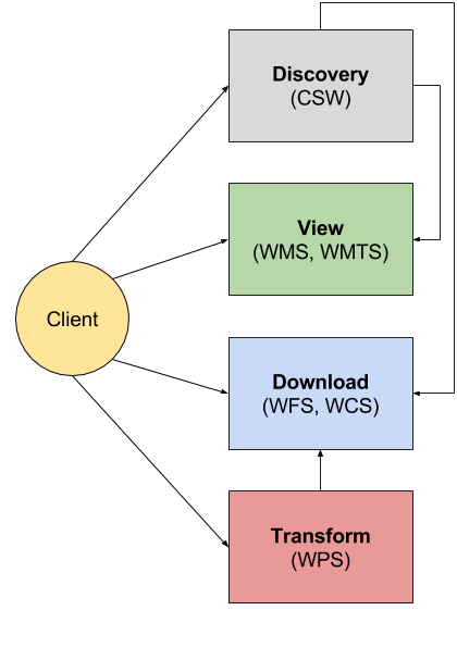
Protocols define how network communication must take place between two systems. The OGC has defined several protocols classified appropriately by INSPIRE in the following classes:
- Discovery services
- View services
- Download services
- Transformation services
Protocols summary view
The idea is simple. A user would first use a Discovery service to locate the data of interest, then would use a view service for a visual inspection. Once satisfied, eventually to download the data for offline usage, or to use a transformation service to perform an online spatial analysis.
Discovery services are implemented using CSW (Catalog Services for the Web), a protocol designed with a standards-based interface to discover, browse, and query metadata of geospatial data. An interaction with a CSW (e.g., GeoNetwork) typically leads to find links to other OGC protocols to view and download the data. GeoServer has a CSW module that’s still in its infancy, this training does not yet cover it.
View services are implemented using WMS (Web Map Service) and WMTS (Web Map Tile Service), a stanard HTTP protocols that allow a client to view maps images from one or more distributed geospatial databases. The latter are the easiest services to use and understand, they simply provide a list of maps that can be displayed and combined in a browser application, eventually queried, but not modified or changed. You can learn more about WMS in Pretty maps with GeoServer and about WMTS in Caching maps with GeoWebCache
Download services are implemented using WFS (Web Feature Service) and WCS (Web Coverage Service, protocols allow downloading the source data behind maps, either in vector (WFS) or raster (WCS) formats, allowing to perform the following extra actions during the download:
- Spatial filtering (e.g., by bounding box), thus extracting only a certain subset of the data;
- Alphanumeric filtering (only WFS), or extraction by time (also WCS);
- Selection of attributes of interest (WFS) or bands (WCS);
- Change of map projection;
- Rescaling (only for WCS, e.g., allows to download a version of raster at a lower resolution to save on bandwidth).
More details on WFS can be found in Delivering Raster Data while details on WCS can be found in WCS requests for multidimensional coverages.
Transformation services are used to perform online spatial analysis on vector and raster data. The protocol used in this case is WPS (Web Processing Service) and will be covered in _geoserver.wps
Common requests in protocol standards
A client makes requests in order to interact with a service. Each request has a different role also different services show different calls, but there are a few common points.
Here are common requests and their meaning:
- GetCapabilities: this is the only request present in all protocols. It returns a long XML document describing what the server can do and what it contains. It allows the client to discover which parts of a protocol are actually supported (some can be optional), which formats are supported in return, and which “subjects” or “contents” are available in the server (might be maps, vector data, raster data, and so on)
- Describe<Content>: present in some protocols. It allows to get some further information about a particular content delivered by the server. For example, DescribeFeatureType in WFS provides the list of attributes for a particular vector layer, while DescribeProcess in WPS describes inputs and outputs of a spatial analysis process.
- Get<Content>: this call retrieves the particular content, normally providing extra parameters to control the production/extraction of the output. For example, we have GetMap in WMS, GetFeature in WFS, and GetCoverage in WCS.
These requests are normally performed in sequence by the client. Each one enables the usage of the next one.
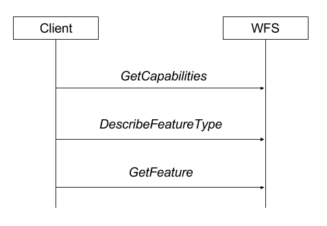
A client interacting with a WFS server
Ways to encode requests
Requests in OGC protocols can normally be performed using two different paradigms:
KVP or Key Value Pair. It’s a simple URL that supports all the requests parameters as pairs of keys and values in the query string. The HTTP request is a GET in this case. Here is an example of a WFS GetFeature in KVP mode:
http://demo.geo-solutions.it/geoserver/wfs?
    request=GetFeature&
    version=1.1.0&
    typeName=topp:states&
    propertyName=STATE_NAME,PERSONS&
    BBOX=-75.102613,40.212597,-72.361859,41.512517,EPSG:4326
XML POST, contains a XML document describing the request and sent to the server as a HTTP POST request. Here is an example of a WFS GetFeature using HTTP POST mode:
<wfs:GetFeature service="WFS" version="1.0.0"
    outputFormat="GML2"
    xmlns:topp="http://www.openplans.org/topp"
    xmlns:wfs="http://www.opengis.net/wfs"
    xmlns:ogc="http://www.opengis.net/ogc"
    xmlns:gml="http://www.opengis.net/gml"
    xmlns:xsi="http://www.w3.org/2001/XMLSchema-instance"
    xsi:schemaLocation="http://www.opengis.net/wfs
                        http://schemas.opengis.net/wfs/1.0.0/WFS-basic.xsd">
    <wfs:Query typeName="topp:states">
      <ogc:PropertyName>topp:STATE_NAME</ogc:PropertyName>
      <ogc:PropertyName>topp:PERSONS</ogc:PropertyName>
      <ogc:Filter>
        <ogc:BBOX>
          <ogc:PropertyName>the_geom</ogc:PropertyName>
          <gml:Box srsName="http://www.opengis.net/gml/srs/epsg.xml#4326">
             <gml:coordinates>-75.102613,40.212597 -72.361859,41.512517</gml:coordinates>
          </gml:Box>
        </ogc:BBOX>
     </ogc:Filter>s
    </wfs:Query>
  </wfs:GetFeature>