
Features Service basics
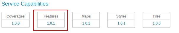
The OGC API Features Service is accessed via the FEATURES version 1.0 link on the home page.
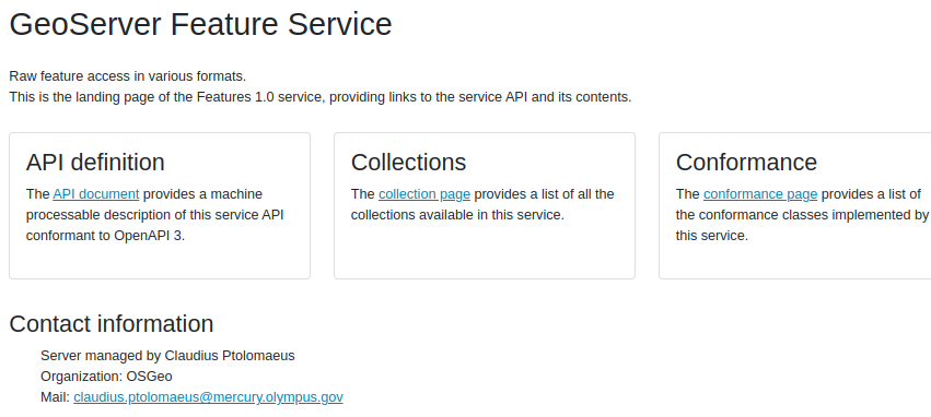
The landing page (at http://localhost:8083/geoserver/ogc/features/v1) provides clients with a starting point for using the API, through a collection of resources, with links for navigation between content. The following screenshot shows the HTML representation of the landing page.
The page provides also link for other output formats, namely:
application/json(athttp://localhost:8083/geoserver/ogc/features/v1?f=application/json) output format provides a collection ofjsondocuments, with references between each document for programmatic access by web developers.application/x-yaml(athttp://localhost:8083/geoserver/ogc/features/v1?f=application/x-yaml) output format will provide a collection ofyamldocuments, with references between each document for programmatic access.Yamlis not specified by the standard but is additionally provided by the GeoServer service implementation.
The service title and description are provided by the existing Web Feature Service (WFS) settings.
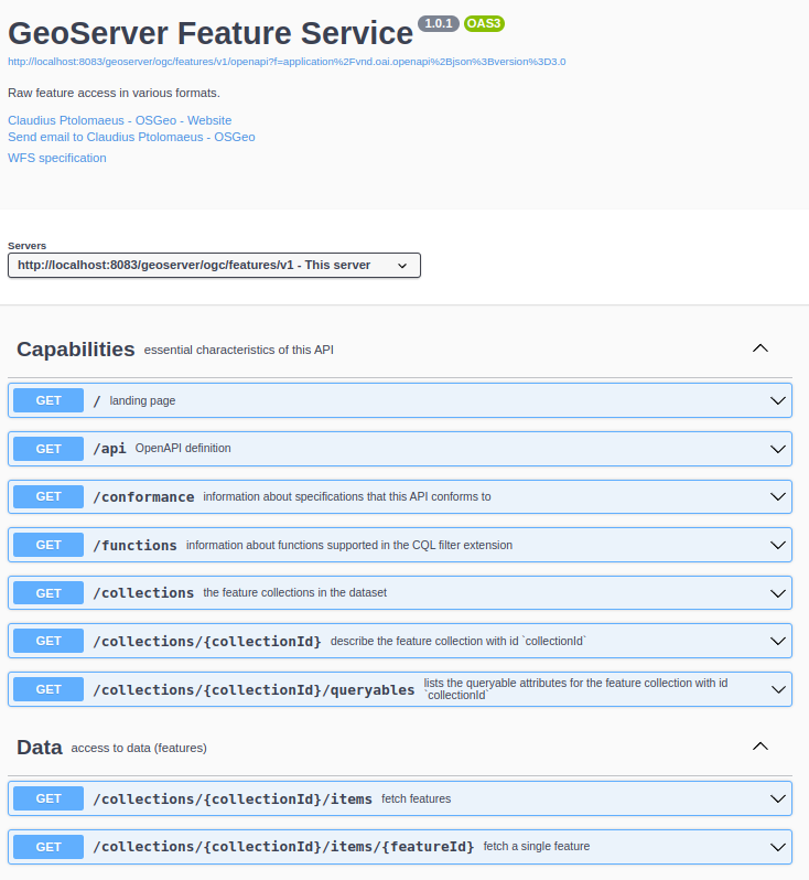
The API definition provides an OpenAPI description of the available resources and the operation that can be perfomed on them. The following is the HTML representation:
Collections and Items
OGC API - Features provides access to collections of geospatial data. A collection is a generic concept for a set of related resources/items.
A collection can thus be a Feature Collection when each of its items is a Feature.
For each configured vector layer in GeoServer a collection is provided. Each collection entry is described using the corresponding layer details: title, description, geographic extent.
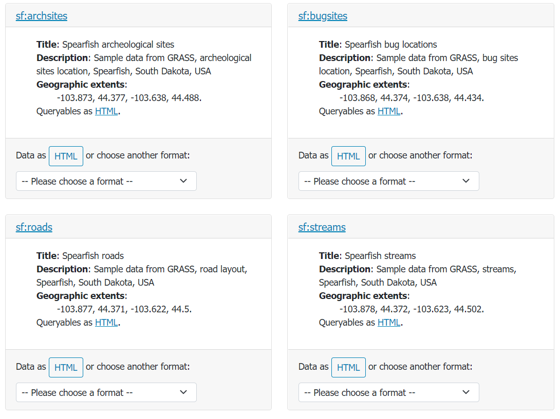
Collections page available at http://localhost:8083/geoserver/ogc/features/v1/collections?f=text/html
From the collection page it is possible to request a collection definition to retrieve more details
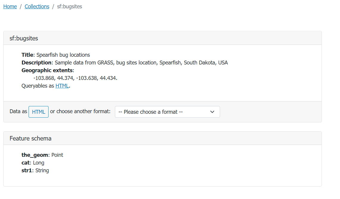
Bugsites collection page available at http://localhost:8083/geoserver/ogc/features/v1/collections/bugsites?f=text/html
and retrieve the collection data. Data can be browsed as web pages, or downloaded in a range of formats such as GeoJSON and GML documents.
Data can be requested by adding /items path to the collection url, eg. http://localhost:8083/geoserver/ogc/features/v1/collections/bugsites/items.
A single item can be requested by adding also the Feature/Item id to the url eg. http://localhost:8083/geoserver/ogc/features/v1/collections/bugsites/items/bugsites.1.
HTML output
The following is the HTML output for the bugsites items collection.
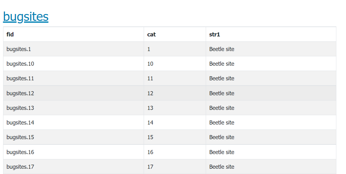
Bugsites items HTML representation, available at http://localhost:8083/geoserver/ogc/features/v1/collections/bugsites/items.
GeoJSON
Feature Service supports application/geo+json. In addition to a JSON representation of a collection, it provides also a links JSON array comrpising urls to all the output formats for which the collection and the collection description are available.
Moreover if pagination (see the next section) has been used a link to the next pagined result will be provided.
The following is the bugsites application/geo+json collection representation available at http://localhost:8083/geoserver/ogc/features/v1/collections/sf:bugsites/items?f=application%2Fgeo%2Bjson.
 {
  "type":"FeatureCollection",
  "features":[
     {
        "type":"Feature",
        "id":"bugsites.1",
        "geometry":{
           "type":"Point",
           "coordinates":[
              -103.86761148,
              44.38484141
           ]
        },
        "geometry_name":"the_geom",
        "properties":{
           "cat":1,
           "str1":"Beetle site"
        }
     },
     {
        "type":"Feature",
        "id":"bugsites.10",
        "geometry":{
           "type":"Point",
           "coordinates":[
              -103.85881675,
              44.38906627
           ]
        },
        "geometry_name":"the_geom",
        "properties":{
           "cat":10,
           "str1":"Beetle site"
        }
     },
     {
        "type":"Feature",
        "id":"bugsites.11",
        "geometry":{
           "type":"Point",
           "coordinates":[
              -103.85882875,
              44.37746168
           ]
        },
        "geometry_name":"the_geom",
        "properties":{
           "cat":11,
           "str1":"Beetle site"
        }
     }
  ],
  "numberMatched":90,
  "numberReturned":50,
  "timeStamp":"2021-09-15T14:19:23.383Z",
  "links":[
     {
        "title":"Next page",
        "type":"application/geo+json",
        "rel":"next",
        "href":"http://localhost:8083/geoserver/ogc/features/v1/collections/sf%3Abugsites/items?limit=50&f=application%2Fgeo%2Bjson&startIndex=50"
     },
     {
        "title":"This document as text/html",
        "type":"text/html",
        "rel":"alternate",
        "href":"http://localhost:8083/geoserver/ogc/features/v1/collections/sf%3Abugsites/items?f=text%2Fhtml"
     },
     {
        "title":"This document as application/vnd.google-earth.kml+xml",
        "type":"application/vnd.google-earth.kml+xml",
        "rel":"alternate",
        "href":"http://localhost:8083/geoserver/ogc/features/v1/collections/sf%3Abugsites/items?f=application%2Fvnd.google-earth.kml%2Bxml"
     },
     {
        "title":"This document",
        "type":"application/geo+json",
        "rel":"self",
        "href":"http://localhost:8083/geoserver/ogc/features/v1/collections/sf%3Abugsites/items?f=application%2Fgeo%2Bjson"
     },
     {
        "title":"This document as application/stac+json",
        "type":"application/stac+json",
        "rel":"alternate",
        "href":"http://localhost:8083/geoserver/ogc/features/v1/collections/sf%3Abugsites/items?f=application%2Fstac%2Bjson"
     },
     {
        "title":"This document as application/gml+xml;version=3.2",
        "type":"application/gml+xml;version=3.2",
        "rel":"alternate",
        "href":"http://localhost:8083/geoserver/ogc/features/v1/collections/sf%3Abugsites/items?f=application%2Fgml%2Bxml%3Bversion%3D3.2"
     },
     {
        "title":"This document as text/csv",
        "type":"text/csv",
        "rel":"alternate",
        "href":"http://localhost:8083/geoserver/ogc/features/v1/collections/sf%3Abugsites/items?f=text%2Fcsv"
     },
     {
        "title":"This document as application/json",
        "type":"application/json",
        "rel":"alternate",
        "href":"http://localhost:8083/geoserver/ogc/features/v1/collections/sf%3Abugsites/items?f=application%2Fjson"
     },
     {
        "title":"This document as application/cbor",
        "type":"application/cbor",
        "rel":"alternate",
        "href":"http://localhost:8083/geoserver/ogc/features/v1/collections/sf%3Abugsites/items?f=application%2Fcbor"
     },
     {
        "title":"The collection description as application/x-yaml",
        "type":"application/x-yaml",
        "rel":"collection",
        "href":"http://localhost:8083/geoserver/ogc/features/v1/collections/sf%3Abugsites?f=application%2Fx-yaml"
     },
     {
        "title":"The collection description as application/json",
        "type":"application/json",
        "rel":"collection",
        "href":"http://localhost:8083/geoserver/ogc/features/v1/collections/sf%3Abugsites?f=application%2Fjson"
     },
     {
        "title":"The collection description as application/cbor",
        "type":"application/cbor",
        "rel":"collection",
        "href":"http://localhost:8083/geoserver/ogc/features/v1/collections/sf%3Abugsites?f=application%2Fcbor"
     },
     {
        "title":"The collection description as text/html",
        "type":"text/html",
        "rel":"collection",
        "href":"http://localhost:8083/geoserver/ogc/features/v1/collections/sf%3Abugsites?f=text%2Fhtml"
     }
  ]
}
When a single item is requested it will appear as a single JSON object.
The following is a bugsites item application/geo+json representation available at http://localhost:8083/geoserver/ogc/features/v1/collections/sf:bugsites/items/bugsites.1?f=application%2Fgeo%2Bjson.
  {
  "type":"Feature",
  "id":"bugsites.1",
  "geometry":{
     "type":"Point",
     "coordinates":[
        -103.86761148,
        44.38484141
     ]
  },
  "geometry_name":"the_geom",
  "properties":{
     "cat":1,
     "str1":"Beetle site"
  },
  "links":[
     {
        "title":"This document as text/html",
        "type":"text/html",
        "rel":"alternate",
        "href":"http://localhost:8083/geoserver/ogc/features/v1/collections/sf%3Abugsites/items/bugsites.1?f=text%2Fhtml"
     },
     {
        "title":"This document as application/vnd.google-earth.kml+xml",
        "type":"application/vnd.google-earth.kml+xml",
        "rel":"alternate",
        "href":"http://localhost:8083/geoserver/ogc/features/v1/collections/sf%3Abugsites/items/bugsites.1?f=application%2Fvnd.google-earth.kml%2Bxml"
     },
     {
        "title":"This document",
        "type":"application/geo+json",
        "rel":"self",
        "href":"http://localhost:8083/geoserver/ogc/features/v1/collections/sf%3Abugsites/items/bugsites.1?f=application%2Fgeo%2Bjson"
     }
  ]
}
GML output
GeoServer also provides a GML output.
The following is the gml+xml;version=3.2 representation available at
http://localhost:8083/geoserver/ogc/features/v1/collections/sf:bugsites/items?f=application%2Fgml%2Bxml%3Bversion%3D3.2&limit=3.
<?xml version="1.0" encoding="UTF-8"?>
<wfs:FeatureCollection xmlns:xs="http://www.w3.org/2001/XMLSchema" xmlns:sf="http://www.openplans.org/spearfish" xmlns:wfs="http://www.opengis.net/wfs/2.0" xmlns:gml="http://www.opengis.net/gml/3.2" xmlns:xsi="http://www.w3.org/2001/XMLSchema-instance" next="http://localhost:8083/geoserver/ogc/features/v1/collections/sf%3Abugsites/items?limit=3&f=application%2Fgml%2Bxml%3Bversion%3D3.2&startIndex=3" numberMatched="90" numberReturned="3" timeStamp="2021-09-24T15:04:32.259Z" xsi:schemaLocation="http://www.opengis.net/wfs/2.0 http://localhost:8083/geoserver/schemas/wfs/2.0/wfs.xsd http://www.openplans.org/spearfish http://localhost:8083/geoserver/wfs?service=WFS&version=2.0.0&request=DescribeFeatureType&typeName=sf%3Abugsites http://www.opengis.net/gml/3.2 http://localhost:8083/geoserver/schemas/gml/3.2.1/gml.xsd">
<wfs:member>
<sf:bugsites gml:id="bugsites.1">
<sf:the_geom>
<gml:Point srsName="http://www.opengis.net/gml/srs/epsg.xml#4326" srsDimension="2" gml:id="bugsites.1.the_geom">
<gml:pos>-103.86761148 44.38484141</gml:pos>
</gml:Point>
</sf:the_geom>
<sf:cat>1</sf:cat>
<sf:str1>Beetle site</sf:str1>
</sf:bugsites>
</wfs:member>
<wfs:member>
<sf:bugsites gml:id="bugsites.10">
<sf:the_geom>
<gml:Point srsName="http://www.opengis.net/gml/srs/epsg.xml#4326" srsDimension="2" gml:id="bugsites.10.the_geom">
<gml:pos>-103.85881675 44.38906627</gml:pos>
</gml:Point>
</sf:the_geom>
<sf:cat>10</sf:cat>
<sf:str1>Beetle site</sf:str1>
</sf:bugsites>
</wfs:member>
<wfs:member>
<sf:bugsites gml:id="bugsites.11">
<sf:the_geom>
<gml:Point srsName="http://www.opengis.net/gml/srs/epsg.xml#4326" srsDimension="2" gml:id="bugsites.11.the_geom">
<gml:pos>-103.85882875 44.37746168</gml:pos>
</gml:Point>
</sf:the_geom>
<sf:cat>11</sf:cat>
<sf:str1>Beetle site</sf:str1>
</sf:bugsites>
</wfs:member>
</wfs:FeatureCollection>