
Decorating a Map
WMS Decorations provide a framework for visually annotating images from WMS with absolute, rather than spatial, positioning. This example of decoration include scaleline, legends, and image.
Go to $geoserver_data and create a new directory named layouts and create a new file named boulder_ly.xml inside it.
Inside the boulder_ly.xml file enter the following XML (replace
${geoserver_data}with your actual path, e.g.,file://C:/training/geoserver_data):<layout> <decoration type="image" affinity="top,left" offset="45,8" size="64,60"> <option name="url" value="${geoserver_data}/geosolutions-logo-tx.png" /> </decoration> <decoration type="text" affinity="bottom,right" offset="3,3"> <option name="message" value="Boulder City" /> <option name="font-size" value="14" /> <option name="font-color" value="#FFFFFF" /> <option name="halo-radius" value="1" /> <option name="halo-color" value="#000000" /> </decoration> <decoration type="scaleline" affinity="bottom,left" offset="3,3" /> <decoration type="legend" affinity="top,right" offset="6,6" size="auto" /> </layout>
Save and close the file.
Go to the Layer Preview to preview the new map decoration on geosolutions:Mainrd layer. Once the layout boulder_ly.xml is defined, request it by adding format_options=layout:boulder_ly to the request parameters.
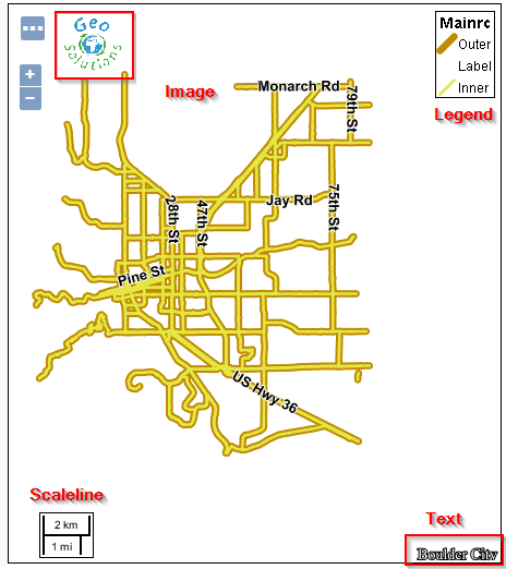
Map decoration
The request:
http://localhost:8083/geoserver/geosolutions/wms?service=WMS&version=1.1.0&request=GetMap&layers=geosolutions:Mainrd&styles=&bbox=3048474.661,1226045.092,3095249.0,1279080.5&width=451&height=512&srs=EPSG:2876&format=application/openlayers&format_options=layout:boulder_ly
Note
Zoom-in until the layer and legend appears since for this layer we have scale_denominator based rules. Also you can apply this format_layout to any layer, but be careful with the overalys since you will have all the legends printed out on the right-top side of the map.