
Z Ordering Features
Z ordering features controls the order in which the features are being loaded and drawn on the map, thus replicating the same above/below relationships found in the reality.
Enabling z-ordering in a single FeatureTypeStyle
The z-ordering is implemented as a new FeatureTypeStyle vendor option, sortBy, which controls in which order the features are extracted from the data source, and thus drawn.
The sortBy syntax is the same as the WFS one, that is, a list of comma separated field names with an optional direction modifier (ascending being the default):
field1 [A|D], field2 [A|D], ... , fieldN [A|D]
Some examples:
- “z”: sorts the features based on the
zfield, ascending (lower z values are drawn first, higher later)- “cat,z D”: sorts the features on the
catattribute, with ascending order, and for those that have the samecatvalue, the sorting is on descendingz- “cat D,z D”: sorts the features on the
catattribute, with descending order, and for those that have the samecatvalue, the sorting is on descendingz
So, if we want to order features based on a single “elevation” attribute we’d be using the following SLD snippet:
...
<sld:FeatureTypeStyle>
  <sld:Rule>
    ...
    <!-- filters and symbolizers here -->
    ...
  </sld:Rule>
  <sld:VendorOption name="sortBy">elevation</sld:VendorOption>
</sld:FeatureTypeStyle>
...
z-ordering across FeatureTypeStyle
It is a common need to perform road casing against a complex road network, which can have its own z-ordering needs (e.g., over and under passes).
Casing is normally achieved by using two separate two FeatureTypeStyle, one drawing a thick line, one drawing a thin one.
Let’s consider a simple data set, made of just three roads:
_=geom:LineString:404000,z:int
Line.1=LINESTRING(0 4, 10 4)|1
Line.2=LINESTRING(0 6, 10 6)|3
Line.3=LINESTRING(7 0, 7 10)|1
Adding a “sortBy” rule to both FeatureTypeStyle objects will achieve no visible result:
<?xml version="1.0" encoding="ISO-8859-1"?>
<StyledLayerDescriptor version="1.0.0"
  xsi:schemaLocation="http://www.opengis.net/sld StyledLayerDescriptor.xsd"
  xmlns="http://www.opengis.net/sld" xmlns:ogc="http://www.opengis.net/ogc"
  xmlns:xlink="http://www.w3.org/1999/xlink" xmlns:xsi="http://www.w3.org/2001/XMLSchema-instance">
  <!-- a named layer is the basic building block of an sld document -->

  <NamedLayer>
    <UserStyle>
      <FeatureTypeStyle>
        <Rule>
          <LineSymbolizer>
            <Stroke>
              <CssParameter name="stroke">#FF0000</CssParameter>
              <CssParameter name="stroke-width">8</CssParameter>
            </Stroke>
          </LineSymbolizer>
        </Rule>
        <sld:VendorOption name="sortBy">z</sld:VendorOption>
      </FeatureTypeStyle>
      <FeatureTypeStyle>
        <Rule>
          <LineSymbolizer>
            <Stroke>
              <CssParameter name="stroke">#FFFFFF</CssParameter>
              <CssParameter name="stroke-width">6</CssParameter>
            </Stroke>
          </LineSymbolizer>
        </Rule>
        <sld:VendorOption name="sortBy">z</sld:VendorOption>
      </FeatureTypeStyle>
    </UserStyle>
  </NamedLayer>
</StyledLayerDescriptor>
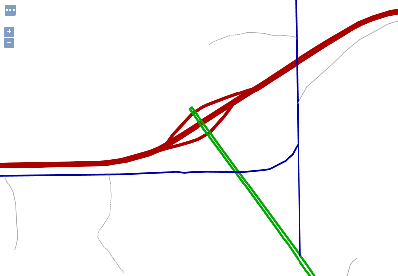
The result will be the following:
This is happening because while the roads are loaded in the right order, Line.1,Line.3,Line.2, they are all drawn with the thick link first, and then the code will start over, and draw them all with the thin line.
In order to get both casing and z-ordering to work a new vendor option, sortByGroup, needs to be added to both FeatureTypeStyle, grouping them in a single z-ordering draw.
<?xml version="1.0" encoding="ISO-8859-1"?>
<StyledLayerDescriptor version="1.0.0"
  xsi:schemaLocation="http://www.opengis.net/sld StyledLayerDescriptor.xsd"
  xmlns="http://www.opengis.net/sld" xmlns:ogc="http://www.opengis.net/ogc"
  xmlns:xlink="http://www.w3.org/1999/xlink" xmlns:xsi="http://www.w3.org/2001/XMLSchema-instance">

  <NamedLayer>
    <UserStyle>
      <FeatureTypeStyle>
        <Rule>
          <LineSymbolizer>
            <Stroke>
              <CssParameter name="stroke">#FF0000</CssParameter>
              <CssParameter name="stroke-width">8</CssParameter>
            </Stroke>
          </LineSymbolizer>
        </Rule>
        <sld:VendorOption name="sortBy">z</sld:VendorOption>
        <sld:VendorOption name="sortByGroup">roads</sld:VendorOption>
      </FeatureTypeStyle>
      <FeatureTypeStyle>
        <Rule>
          <LineSymbolizer>
            <Stroke>
              <CssParameter name="stroke">#FFFFFF</CssParameter>
              <CssParameter name="stroke-width">6</CssParameter>
            </Stroke>
          </LineSymbolizer>
        </Rule>
        <sld:VendorOption name="sortBy">z</sld:VendorOption>
        <sld:VendorOption name="sortByGroup">roads</sld:VendorOption>
      </FeatureTypeStyle>
    </UserStyle>
  </NamedLayer>
</StyledLayerDescriptor>
The result will be the following:
When grouping is used, the code will first draw Line.1,Line3 with the thick line, then track back and draw them with the thin line, then move to draw Line.2 with the thick line, and finally Line.2 with the thin line, achieving the desired result.
z-ordering across layers
Different layers, such for example roads and rails, can have their features z-ordered together by putting all the FeatureTypeStyle in their styles in the same sortByGroup, provided the following conditions are met:
- The layers are side by side in the WMS request/layer group. In other words, the z-ordering allows to break the WMS specified order only if the layers are directly subsequent in the request. This can be extended to any number of layers, provided the progression of
FeatureTypeStylein the same group is not broken.- There is no FeatureTypeStyle in the layer style that’s breaking the sequence.
Let’s consider an example, with a rails layer having two FeatureTypeStyle, one with a group, the other not:
FeatureTypeStyle id SortByGroup id rails1 linework rails2 none
We then have a roads layer with two FeatureTypeStyle, both in the same group:
FeatureTypeStyle id SortByGroup id road1 linework road2 linework
If the WMS request asks for &layers=roads,rails, then the expanded FeatureTypeStyle list will be:
FeatureTypeStyle id SortByGroup id road1 linework road2 linework rails1 linework rails2 none
As a result, the road1,road2,rails1 will form a single group and this will result in the rails be merged with the roads when z-ordering.
If instead the WMS request asks for &layers=rails,roads, then the expanded FeatureTypeStyle list will be:
FeatureTypeStyle id SortByGroup id rails1 linework rails2 noneroad1 linework road2 linework
The rails2 feature type style breaks the sequence. As a result, the rails will not be z-ordered in the same group as the roads.
z-ordering example in a single FeatureTypeStyle
In this simple exercise we will z-order the features on the layer sf:roads with a category attribute (cat).
Add the following SLD as a new style in GeoServer named sf_roads:
<?xml version="1.0" encoding="UTF-8"?>
<sld:StyledLayerDescriptor xmlns="http://www.opengis.net/sld" xmlns:sld="http://www.opengis.net/sld" xmlns:ogc="http://www.opengis.net/ogc" xmlns:gml="http://www.opengis.net/gml" version="1.0.0">
  <sld:UserLayer>
    <sld:LayerFeatureConstraints>
      <sld:FeatureTypeConstraint/>
    </sld:LayerFeatureConstraints>
    <sld:UserStyle>
      <sld:Name>sf_roads</sld:Name>
      <sld:Title/>
      <sld:FeatureTypeStyle>
        <sld:Name>sf_roads</sld:Name>
        <sld:FeatureTypeName>Feature</sld:FeatureTypeName>
        <sld:SemanticTypeIdentifier>generic:geometry</sld:SemanticTypeIdentifier>
        <sld:SemanticTypeIdentifier>simple</sld:SemanticTypeIdentifier>
        <sld:Rule>
          <sld:Name>Cat1</sld:Name>
          <ogc:Filter>
            <ogc:PropertyIsEqualTo>
              <ogc:PropertyName>cat</ogc:PropertyName>
              <ogc:Literal>1</ogc:Literal>
            </ogc:PropertyIsEqualTo>
          </ogc:Filter>
          <sld:LineSymbolizer>
            <sld:Stroke>
              <sld:CssParameter name="stroke">#AA0000</sld:CssParameter>
              <sld:CssParameter name="stroke-linecap">round</sld:CssParameter>
              <sld:CssParameter name="stroke-linejoin">round</sld:CssParameter>
              <sld:CssParameter name="stroke-width">6.0</sld:CssParameter>
            </sld:Stroke>
          </sld:LineSymbolizer>
        </sld:Rule>
        <sld:Rule>
          <sld:Name>Cat2</sld:Name>
          <ogc:Filter>
            <ogc:PropertyIsEqualTo>
              <ogc:PropertyName>cat</ogc:PropertyName>
              <ogc:Literal>2</ogc:Literal>
            </ogc:PropertyIsEqualTo>
          </ogc:Filter>
          <sld:LineSymbolizer>
            <sld:Stroke>
              <sld:CssParameter name="stroke">#00AA00</sld:CssParameter>
              <sld:CssParameter name="stroke-linecap">round</sld:CssParameter>
              <sld:CssParameter name="stroke-linejoin">round</sld:CssParameter>
              <sld:CssParameter name="stroke-width">4.0</sld:CssParameter>
            </sld:Stroke>
          </sld:LineSymbolizer>
        </sld:Rule>
        <sld:Rule>
          <sld:Name>Cat3</sld:Name>
          <ogc:Filter>
            <ogc:PropertyIsEqualTo>
              <ogc:PropertyName>cat</ogc:PropertyName>
              <ogc:Literal>3</ogc:Literal>
            </ogc:PropertyIsEqualTo>
          </ogc:Filter>
          <sld:LineSymbolizer>
            <sld:Stroke>
              <sld:CssParameter name="stroke">#0000AA</sld:CssParameter>
              <sld:CssParameter name="stroke-linecap">round</sld:CssParameter>
              <sld:CssParameter name="stroke-linejoin">round</sld:CssParameter>
              <sld:CssParameter name="stroke-width">3.0</sld:CssParameter>
            </sld:Stroke>
          </sld:LineSymbolizer>
        </sld:Rule>
        <sld:Rule>
          <sld:Name>Cat4</sld:Name>
          <ogc:Filter>
            <ogc:PropertyIsEqualTo>
              <ogc:PropertyName>cat</ogc:PropertyName>
              <ogc:Literal>4</ogc:Literal>
            </ogc:PropertyIsEqualTo>
          </ogc:Filter>
          <sld:LineSymbolizer>
            <sld:Stroke>
              <sld:CssParameter name="stroke">#AAAAAA</sld:CssParameter>
              <sld:CssParameter name="stroke-linecap">round</sld:CssParameter>
              <sld:CssParameter name="stroke-linejoin">round</sld:CssParameter>
              <sld:CssParameter name="stroke-width">1</sld:CssParameter>
            </sld:Stroke>
          </sld:LineSymbolizer>
        </sld:Rule>
        <sld:Rule>
          <sld:Name>Cat5</sld:Name>
          <ogc:Filter>
            <ogc:PropertyIsEqualTo>
              <ogc:PropertyName>cat</ogc:PropertyName>
              <ogc:Literal>5</ogc:Literal>
            </ogc:PropertyIsEqualTo>
          </ogc:Filter>
          <sld:LineSymbolizer>
            <sld:Stroke>
              <sld:CssParameter name="stroke">#AAAAAA</sld:CssParameter>
              <sld:CssParameter name="stroke-linecap">round</sld:CssParameter>
              <sld:CssParameter name="stroke-linejoin">round</sld:CssParameter>
              <sld:CssParameter name="stroke-dasharray">2.0 </sld:CssParameter>
              <sld:CssParameter name="stroke-width">1</sld:CssParameter>
            </sld:Stroke>
          </sld:LineSymbolizer>
        </sld:Rule>
        <!--sld:VendorOption name="sortBy">cat</sld:VendorOption-->
      </sld:FeatureTypeStyle>
    </sld:UserStyle>
  </sld:UserLayer>
</sld:StyledLayerDescriptor>
Note
The CSS equivalent of this style is the following
* {
  stroke-linecap: round;
  stroke-linejoin: round;
  /* UNCOMMENT THE LINE BELOW TO ENABLE SORT */
  /* sort-by: 'cat'; */
}

[cat='1'] {
  stroke: #AA0000;
  stroke-width: 6.0;
}

[cat='2'] {
  stroke: #00AA00;
  stroke-width: 4.0;
}

[cat='3'] {
  stroke: #0000AA;
  stroke-width: 3.0;
}

[cat='4'] {
  stroke: #AAAAAA;
  stroke-width: 1.0;
}

[cat='5'] {
  stroke: #AAAAAA;
  stroke-width: 1.0;
  stroke-dasharray: 2.0;
}
Perform the following WMS request:
http://localhost:8083/geoserver/sf/wms?service=WMS&version=1.1.0&request=GetMap&layers=sf:roads&styles=sf_roads&bbox=599244,4924218,601038,4926469&width=800&height=600&srs=EPSG:26713&format=application/openlayers
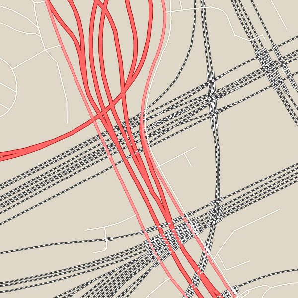
The result should be similar to this image (problematic areas are circled in gray):

As you can see red, green and blue road segments are not properly rendered. These segments have respectively categories of 1, 2 and 3. To achieve a proper renderization for this layer we need to perform a small change in the SLD enabling the z-order capability.
On GeoServer go to Styles and open again the style sf_roads for edition.
Locate the following section and uncomment the sortBy definition VendorOption:
...
  </sld:Rule>
  <!--sld:VendorOption name="sortBy">cat</sld:VendorOption-->
</sld:FeatureTypeStyle>
...
When done click Apply. The change should look like this:
...
  </sld:Rule>
  <sld:VendorOption name="sortBy">cat</sld:VendorOption>
</sld:FeatureTypeStyle>
...
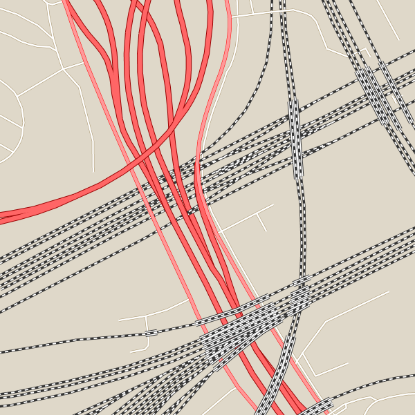
Make again the same previous request and zoom for more detail:
Note
You might need to use a browser incognito window or clear browser cache in order to avoid returning a cached version of the previous image
http://localhost:8083/geoserver/sf/wms?service=WMS&version=1.1.0&request=GetMap&layers=sf:roads&styles=sf_roads&bbox=599244,4924218,601038,4926469&width=800&height=600&srs=EPSG:26713&format=application/openlayers
The result should now be in accordance to cat attribute definition for this layer:
Now road segments are properly rendered following their cat property as the rendering order.