
Vector Processes
As briefly introduced in GeoServer WPS Implementation and Demo Builder section, the WPS supports several types of vectorial/geometric processes.
We can mainly classify them into three big types:
JTS Processes; a straight mapping of the basic JTS geometry functions into WPS ProcessesQuery Oriented Processes; those kind of processes can be seen as an extension of the WFS. Throught them we can issue queries and complex functions to any kind of geometries, external too.Geometric Processes; geometric functions working on both internal and external resources.
Lets try some of them in order to better understand the GeoServer WPS capabilities.
Note
For most of the exercises we will start using the Demo WPS Request Builder in order to easily build a start-up ExecuteProcess document which can be further extended in order to refine the WPS query.
JTS Processes
Lets see some examples of JTS Processes mapped by GeoServer WPS.
JTS:intersection
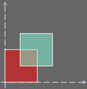
The JTS:intersection process takes two geometries as inputs, a and b, and computes the intersection between them.
With this simple exercise we are going to let the WPS give us an intersection polygon between two simple square polygons, like depicted in the figure below.
Once started the GeoServer, go to the
Demo WPS Request Builderinterface, and selectJTS:intersectionfrom the firstcombo-box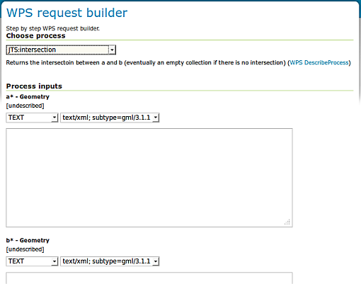
Demo WPS Request Builder interface for JTS:intersection process
The interface asks for two mandatory parameters,
aandb, which must be geometries. Chooseapplication/WKTfor all input and output parameters and insert the following inputs foraandba --> POLYGON((0 0, 0 10, 10 10, 10 0, 0 0)) b --> POLYGON((5 5, 5 15, 15 15, 15 5, 5 5))
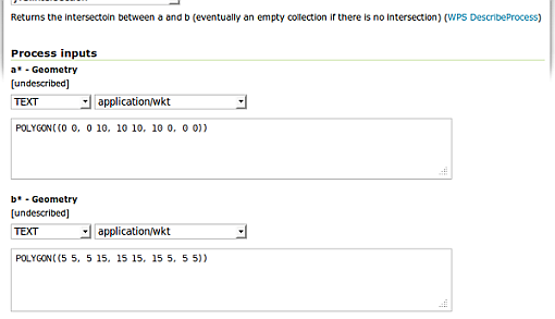
Demo WPS Request Builder interface for JTS:intersection process - input parameters
We expect to get back a polygon representing the intersection between
aandbwhich should bePOLYGON ((5 10, 10 10, 10 5, 5 5, 5 10))
Click on
Execute Processafter having selectedapplication/WKTas type of the generated result.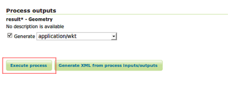
Demo WPS Request Builder interface for JTS:intersection process - Execute Process
After few instants, the browsers returns a file. Open it with a text editor, and confirm that it contains the espected result.
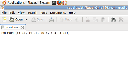
Demo WPS Request Builder interface for JTS:intersection process - Execute Process outcome
Click now on the
Generate XML from process inputs/outputsbutton in order to let the Demo WPS Request Builder generate the ExecuteProcess XML document for us. Should appear a window containing the following automatically generated XML
<?xml version="1.0" encoding="UTF-8"?>
<wps:Execute version="1.0.0" service="WPS" xmlns:xsi="http://www.w3.org/2001/XMLSchema-instance" xmlns="http://www.opengis.net/wps/1.0.0" xmlns:wfs="http://www.opengis.net/wfs" xmlns:wps="http://www.opengis.net/wps/1.0.0" xmlns:ows="http://www.opengis.net/ows/1.1" xmlns:gml="http://www.opengis.net/gml" xmlns:ogc="http://www.opengis.net/ogc" xmlns:wcs="http://www.opengis.net/wcs/1.1.1" xmlns:xlink="http://www.w3.org/1999/xlink" xsi:schemaLocation="http://www.opengis.net/wps/1.0.0 http://schemas.opengis.net/wps/1.0.0/wpsAll.xsd">
  <ows:Identifier>JTS:intersection</ows:Identifier>
  <wps:DataInputs>
        <wps:Input>
          <ows:Identifier>a</ows:Identifier>
          <wps:Data>
                <wps:ComplexData mimeType="application/wkt">
                        <![CDATA[POLYGON((0 0, 0 10, 10 10, 10 0, 0 0))]]>
                </wps:ComplexData>
          </wps:Data>
        </wps:Input>
        <wps:Input>
          <ows:Identifier>b</ows:Identifier>
          <wps:Data>
                <wps:ComplexData mimeType="application/wkt">
                        <![CDATA[POLYGON((5 5, 5 15, 15 15, 15 5, 5 5))]]>
                </wps:ComplexData>
          </wps:Data>
        </wps:Input>
  </wps:DataInputs>
  <wps:ResponseForm>
        <wps:RawDataOutput mimeType="application/wkt">
          <ows:Identifier>result</ows:Identifier>
        </wps:RawDataOutput>
  </wps:ResponseForm>
</wps:Execute>
This document can be POSTED via HTTP to the http://localhost:8083/geoserver/ows? address in order to obtain the same results. Give it a try using Curl as explained in the previous section .
Note
Notice that the input WKTs must be included into a
<![CDATA[...]]>element. The Builder automatically does this for you.
Query Oriented Processes
Examples of Query Oriented Processes are for instance:
gs:Aggregate; count/avg/max/median/min/stddev/sum on a feature collectiongs:Count; like WFS Hits, but on whatever sourcegs:Bounds; bounds of whatever source, missing from WFSgs:Query; query any source like WFSgs:Unique; unique values of an attributegs:Nearest; find the nearest features
gs:Aggregate
During this exercise we are going to:
- Perform an Aggregate operation on the
geosolutions:statesinternal GeoServer resource; in particular we will compute some statistics on thePERSONSattribute- Provide more than one input to the process
Once started the GeoServer, go to the
Demo WPS Request Builderinterface, and selectgs:Aggregatefrom the firstcombo-box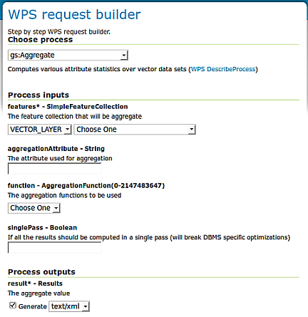
Demo WPS Request Builder interface for gs:Aggregate process
Since we want to access the internal
geosolutions:statesGeoServer layer, for thefeaturesinput parameter select the layer using thecombo-boxand leavingVECTOR_LAYERas selection. Moreover insert the name of the attribute where we want to perform the operations,PERSONS, on thetext-fieldbelow, namedaggregationAttribute. Also set thesinglePassparameter to false in order to avoid to execute all the operations in a single step.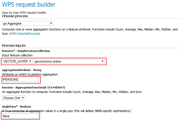
Demo WPS Request Builder interface for gs:Aggregate process - Layer and aggregation attribute selection
Now, we want the Aggregation Process to perform three operations over the
geosolutions:states - PERSONSattribute,Min,MaxandSum.Warning
The Demo WPS Request Builder GUI limits us to choose just one operation (only one Process input per type), so what we will do is to let it generate the base ExecuteProcess Document for us, and then we will modify it in order to match our needs.
Choose
Minfrom the Aggregation Functioncombo-boxand then select theGenerate XML from process inputs/outputsbutton in order to get the ExecuteProcess XML document.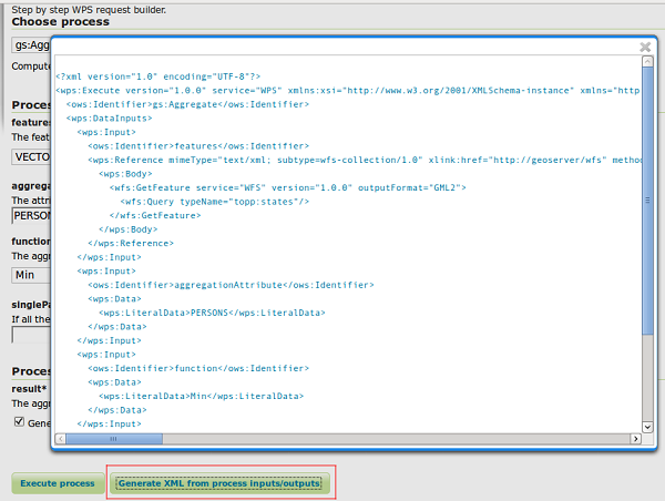
Demo WPS Request Builder interface for gs:Aggregate process - Getting the ExecuteProcess XML base document
Open the
request.xmlfile from the wps section, and cut-and-paste the provided XML into it :<?xml version="1.0" encoding="UTF-8"?> <wps:Execute version="1.0.0" service="WPS" xmlns:xsi="http://www.w3.org/2001/XMLSchema-instance" xmlns="http://www.opengis.net/wps/1.0.0" xmlns:wfs="http://www.opengis.net/wfs" xmlns:wps="http://www.opengis.net/wps/1.0.0" xmlns:ows="http://www.opengis.net/ows/1.1" xmlns:gml="http://www.opengis.net/gml" xmlns:ogc="http://www.opengis.net/ogc" xmlns:wcs="http://www.opengis.net/wcs/1.1.1" xmlns:xlink="http://www.w3.org/1999/xlink" xsi:schemaLocation="http://www.opengis.net/wps/1.0.0 http://schemas.opengis.net/wps/1.0.0/wpsAll.xsd"> <ows:Identifier>gs:Aggregate</ows:Identifier> <wps:DataInputs> <wps:Input> <ows:Identifier>features</ows:Identifier> <wps:Reference mimeType="text/xml" xlink:href="http://geoserver/wfs" method="POST"> <wps:Body> <wfs:GetFeature service="WFS" version="1.0.0" outputFormat="GML2" xmlns:geosolutions="http://www.geo-solutions.it/workshop"> <wfs:Query typeName="geosolutions:states"/> </wfs:GetFeature> </wps:Body> </wps:Reference> </wps:Input> <wps:Input> <ows:Identifier>aggregationAttribute</ows:Identifier> <wps:Data> <wps:LiteralData>PERSONS</wps:LiteralData> </wps:Data> </wps:Input> <wps:Input> <ows:Identifier>function</ows:Identifier> <wps:Data> <wps:LiteralData>Min</wps:LiteralData> </wps:Data> </wps:Input> <wps:Input> <ows:Identifier>singlePass</ows:Identifier> <wps:Data> <wps:LiteralData>false</wps:LiteralData> </wps:Data> </wps:Input> </wps:DataInputs> <wps:ResponseForm> <wps:RawDataOutput mimeType="text/xml"> <ows:Identifier>result</ows:Identifier> </wps:RawDataOutput> </wps:ResponseForm> </wps:Execute>
Also make sure to insert the correct URL of the GeoServer.
Before issuing the request to the WPS, repeat the
Inputfunction three times, by specifying the three operation we want to be executed by the Aggregation Process, like below :<?xml version="1.0" encoding="UTF-8"?> <wps:Execute version="1.0.0" service="WPS" xmlns:xsi="http://www.w3.org/2001/XMLSchema-instance" xmlns="http://www.opengis.net/wps/1.0.0" xmlns:wfs="http://www.opengis.net/wfs" xmlns:wps="http://www.opengis.net/wps/1.0.0" xmlns:ows="http://www.opengis.net/ows/1.1" xmlns:gml="http://www.opengis.net/gml" xmlns:ogc="http://www.opengis.net/ogc" xmlns:wcs="http://www.opengis.net/wcs/1.1.1" xmlns:xlink="http://www.w3.org/1999/xlink" xsi:schemaLocation="http://www.opengis.net/wps/1.0.0 http://schemas.opengis.net/wps/1.0.0/wpsAll.xsd"> <ows:Identifier>gs:Aggregate</ows:Identifier> <wps:DataInputs> <wps:Input> <ows:Identifier>features</ows:Identifier> <wps:Reference mimeType="text/xml" xlink:href="http://geoserver/wfs" method="POST"> <wps:Body> <wfs:GetFeature service="WFS" version="1.0.0" outputFormat="GML2" xmlns:geosolutions="http://www.geo-solutions.it/workshop"> <wfs:Query typeName="geosolutions:states"/> </wfs:GetFeature> </wps:Body> </wps:Reference> </wps:Input> <wps:Input> <ows:Identifier>aggregationAttribute</ows:Identifier> <wps:Data> <wps:LiteralData>PERSONS</wps:LiteralData> </wps:Data> </wps:Input> <wps:Input> <ows:Identifier>function</ows:Identifier> <wps:Data> <wps:LiteralData>Min</wps:LiteralData> </wps:Data> </wps:Input> <wps:Input> <ows:Identifier>function</ows:Identifier> <wps:Data> <wps:LiteralData>Max</wps:LiteralData> </wps:Data> </wps:Input> <wps:Input> <ows:Identifier>function</ows:Identifier> <wps:Data> <wps:LiteralData>Sum</wps:LiteralData> </wps:Data> </wps:Input> <wps:Input> <ows:Identifier>singlePass</ows:Identifier> <wps:Data> <wps:LiteralData>false</wps:LiteralData> </wps:Data> </wps:Input> </wps:DataInputs> <wps:ResponseForm> <wps:RawDataOutput mimeType="text/xml"> <ows:Identifier>result</ows:Identifier> </wps:RawDataOutput> </wps:ResponseForm> </wps:Execute>
Note
Notice that for
multi-valuedinputs we have to repeat the same input N-times.Execute again the cUrl command from the wps section in order to issue the request to the WPS and get back the results:
<?xml version="1.0" encoding="UTF-8"?>
<AggregationResults>
        <Min>453588.0</Min>
        <Max>2.9760021E7</Max>
        <Sum>2.46881454E8</Sum>
</AggregationResults>
Geometric Processes
Those kind of processes allows us to perform Geometric Processing on complex geometries, like FeatureCollection. Moreover we can provide as inputs not only the GeoServer internal WFS layers, but also external or provided ones.
gs:Clip
The gs:Clip process allows to clip a FeatureCollection into another one. The interesting thing about this process is that differently from the WFS, it gives back the exactly clipped FeatureCollection against the requested input clipping geometry.
That means that it does not make a simple query filter, but clips exactly to the specified shape.
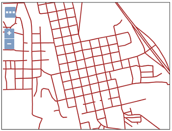
Starting from the full sf:roads FeatureCollection, represented here below
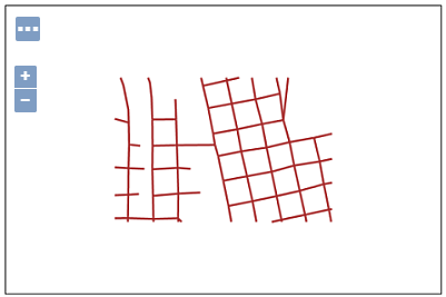
we will issue the WPS gs:Clip process to get back a clipped FeatureCollection to a smaller square area
Once started the GeoServer, go to the
Demo WPS Request Builderinterface, and selectgs:Clipfrom the firstcombo-box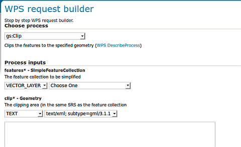
Demo WPS Request Builder interface for gs:Clip process
Select the
VECTOR_LAYERsf:roadsand for the first input, the geometry, select the typeapplication/WKTand insert the followingPOLYGONinto thetext-areaPOLYGON((589800.30577 4927510.97152, 589800.30577 4926799.69435, 590874.57957 4926799.69435, 590874.57957 4927510.97152, 589800.30577 4927510.97152))
Note
The coordinates of the
POLYGONare expressed in the nativeCRSof the FeatureCollection, in this caseEPSG:26713.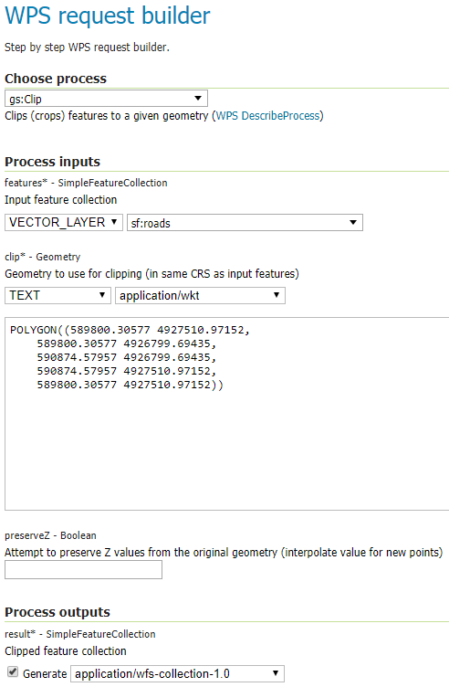
Demo WPS Request Builder interface for gs:Clip process - input parameters
Click on the
Execute Processbutton in order to get back the clipped FeatureCollection inWFS 1.0/GML2dialect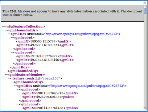
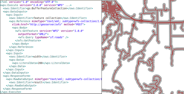
gs:BufferFeatureCollection
The gs:BufferFeatureCollection process applies a buffer of the specified width to all the features of the input FeatureCollection.
Following the same steps of the previous exercise, select from the Demo WPS Request Builder the
gs:BufferFeatureCollectionprocess, select theVECTOR_LAYERsf:roadsand finally specify200as buffer distance.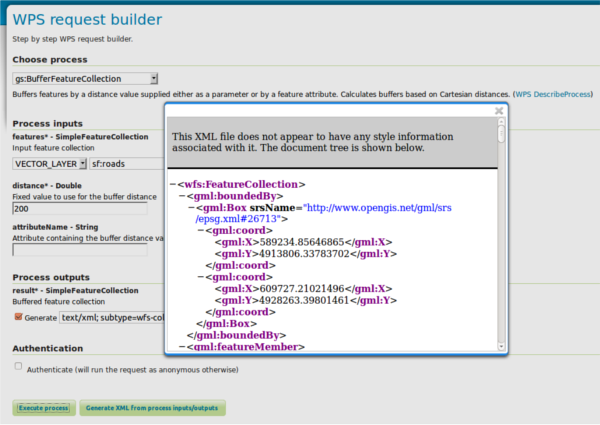
Demo WPS Request Builder interface for gs:BufferFeatureCollection process.
Warning
It will take some time to buffer the whole FeatureCollection.
gs:CollectGeometries and gs:Feature
gs:CollectGeometries and gs:Feature processes allow GeoServer to convert a simple Geometry to a FeatureCollection, and viceversa, collecting all geometries in a FeatureCollection into a single Geometry object.
This is useful when we have processes taking as input a geometry and we need to provide a FeatureCollection and the opposite. Moreover GeoServer automatically uses them to handle those cases when needed.
gs:CollectGeometries; lump up all feature geometries into a geometry collectiongs:Feature; turn a single geometry into a feature collection
From the Demo WPS Request Builder, select the
gs:CollectGeometriesprocess, and specifygeosolutions:poias input layer andapplication:WKTas output format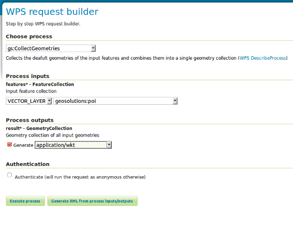
Click on the
Execute Processbutton in order to download the resulting WKT file. Open it with a text editor likegedit. Notice how the input FeatureCollection of POIs has been converted into a simpleMULTIPOINTgeometry:MULTIPOINT ((-74.01046109936333 40.707587626256554), (-74.0108375113659 40.70754683896324), (-74.01053023879955 40.70938711687079), (-74.00857344353275 40.711945649065406), (-74.0118315772888 40.708529961953786), (-74.00153046439813 40.719885123828675))