
Superposition des Données Vectorielles
Dans cette section nous allons apprendre à travailler avec les données vectorielles dans la Carte OpenLayers.
Ajouter une Superposition
Ouvrez le
index.html, créé dans la séction Créer un simple OpenLayers, et remplacez le script d’initialization de la carte avec le suivant:Note
Pour mieux voire la carte utilisée dans cet exemple, vous devez changer le style de la couche geosolutions:bbuildings à l’aide du style
polygon.<script> var bounds = new OpenLayers.Bounds( -105.84, 39.54, -104.46, 40.16 ); var options = { controls: [], maxExtent: bounds, maxResolution: 0.02741796875, projection: "EPSG:4269", units: 'm' }; map = new OpenLayers.Map('map-id', options); var ccounties = new OpenLayers.Layer.WMS( "Counties of Colorado - Untiled", "http://localhost:8083/geoserver/wms", { width: '426', srs: 'EPSG:4269', layers: 'geosolutions:Counties', height: '512', styles: '', format:'image/png' }, {singleTile: true, ratio: 1} ); var bbuildings = new OpenLayers.Layer.WMS( "Boulder buildings - Untiled", "http://localhost:8083/geoserver/wms", { layers: 'geosolutions:bbuildings', format:'image/png', transparent: true, styles: 'polygon' }, {singleTile: true, buffer:0, ratio: 1} ); map.addLayers([ccounties, bbuildings]); // build up all controls map.addControl(new OpenLayers.Control.PanZoomBar({ position: new OpenLayers.Pixel(2, 15) })); map.addControl(new OpenLayers.Control.Navigation()); map.addControl(new OpenLayers.Control.Scale()); map.addControl(new OpenLayers.Control.MousePosition()); map.zoomToExtent(bounds); </script>
Note
Fairtes attention lors lors-que vous introduisez plusieurs couches dans la carte. Charger autant de données peut rendre le navigateur instable s’il n’est pas contrôlé.
Puis remplacez l’étiquette du style en utilisant ce qui suit:
<style type="text/css">
        /* General settings */
        body {
                font-family: Verdana, Geneva, Arial, Helvetica, sans-serif;
                font-size: small;
        }

        /* Map settings */
        #map {
                clear: both;
                position: relative;
                width: 407px;
                height: 512px;
                border: 1px solid black;
        }
</style>
Sauvez le fichier et ouvrez la carte and dans votre navigateur Web à Welcome Page.
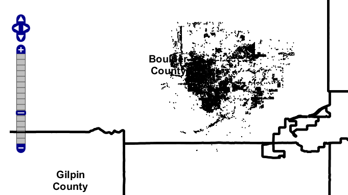
Une carte de Counties of Colorado avec une superposition.
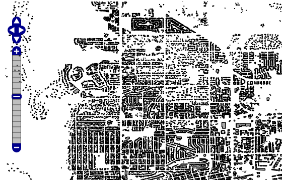
Une carte zoomée Counties of Colorado avec une superposition.
Note
Le code ajouté:
var bbuildings = new OpenLayers.Layer.WMS(
        "Boulder buildings - Untiled", "http://localhost:8083/geoserver/wms",
        {
        layers: 'geosolutions:bbuildings',
        format:'image/png',
        transparent: true,
        styles: 'polygon'
        },
        {singleTile: true, buffer:0, ratio: 1}
);
définit une superposition à travers le parametre
transparentmis entrue.
Ajouter les caractéristiques vectorielles
Ouvrez le
index.htmlet remplacez le scipt d’initialization de la Carte avec ce qui suit:<script> var bounds = new OpenLayers.Bounds( -105.84, 39.54, -104.46, 40.16 ); var options = { controls: [], maxExtent: bounds, maxResolution: 0.02741796875, projection: "EPSG:4269", units: 'm' }; map = new OpenLayers.Map('map-id', options); var ccounties = new OpenLayers.Layer.WMS( "Counties of Colorado - Untiled", "http://localhost:8083/geoserver/wms", { width: '426', srs: 'EPSG:4269', layers: 'geosolutions:ccounties', height: '512', styles: '', format:'image/png' }, {singleTile: true, ratio: 1} ); var bbuildings = new OpenLayers.Layer.WMS( "Boulder buildings - Untiled", "http://localhost:8083/geoserver/wms", { layers: 'geosolutions:bbuildings', format:'image/png', transparent: true, styles: 'polygon' }, {singleTile: true, buffer:0, ratio: 1} ); var bptlandmarks = new OpenLayers.Layer.Vector("bptlandmarks", { strategies: [new OpenLayers.Strategy.Fixed()], protocol: new OpenLayers.Protocol.HTTP({ url: "data/bptlandmarks.json", format: new OpenLayers.Format.GeoJSON() }) }); map.addLayers([ccounties, bbuildings, bptlandmarks]); // build up all controls map.addControl(new OpenLayers.Control.PanZoomBar({ position: new OpenLayers.Pixel(2, 15) })); map.addControl(new OpenLayers.Control.Navigation()); map.addControl(new OpenLayers.Control.Scale()); map.addControl(new OpenLayers.Control.MousePosition()); map.zoomToExtent(bounds); </script>
Sauvez le fichier et ouvrez la carte dans votre navigateur Web à Welcome Page.
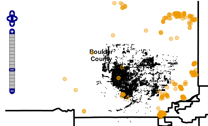
Une carte Counties of Colorado avec points de repère caractéristiques vectorielles.
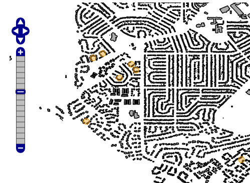
Une carte zoomée Counties of Colorado avec points de repère caractéristiques vectorielles.
Note
Le code ajoint:
var bptlandmarks = new OpenLayers.Layer.Vector("Point landmarks", {
         strategies: [new OpenLayers.Strategy.Fixed()],
         protocol: new OpenLayers.Protocol.HTTP({
                 url: "data/bptlandmarks.json",
                 format: new OpenLayers.Format.GeoJSON()
         })
});
définit une couche vectorielle chargée du fichier JSON. Le fichier bptlandmarks.json est produit par GeoServer en utilisant using la requete suivante:
http://localhost:8083/geoserver/ows?service=WFS&version=1.0.0&request=GetFeature&typeName=geosolutions:bptlandmarks&outputFormat=json&CQL_FILTER=MTFCC=%27C3061%27