
Introduction to the WPS Protocol and Operations
The Web Processing Service (WPS) is a service designed to standardize the way that GIS calculations are made available to the Internet. WPS can describe any calculation including all of its inputs and outputs, and trigger its execution.
The specific processes served up by a WPS implementation are defined by the owner of that implementation. Although WPS was designed to work with spatially referenced data, it can be used with any kind of data.
From another point of view it can be seen as a standard way to perform a Remote Procedure Call (RPC) using XML.
WPS - Startup the service
In order to start the GeoServer WPS enabled (currently version 2.2.x with WPS plugin extension), open up a terminal window and lunch the following command:
service geoserver_trunk start
Warning
This assumes the GeoServer WPS plug-in is already installed. The WPS plugin is normally an extension.
When using Windows installation, install the ‘geoserver-2.2-SNAPSHOT-wps-plugin’ from %TRAINING_ROOT%\data\plugins\. Just decompress the zip file into %CATALINA_BASE%\webapps\geoserver\WEB-INF\lib\ and restart GeoServer.
Wait until the GeoServer has started, you can check the running logs by issuing the following command line:
* Linux

       tail -f ${CATALINA_BASE}/logs/catalina.out

* Windows

       check the windows opened by the startup script
The line Server startup in XXXXX ms means that we are ready to go.
You can verify the correct startup by opening a browser window at:
http://localhost:8083/geoserver
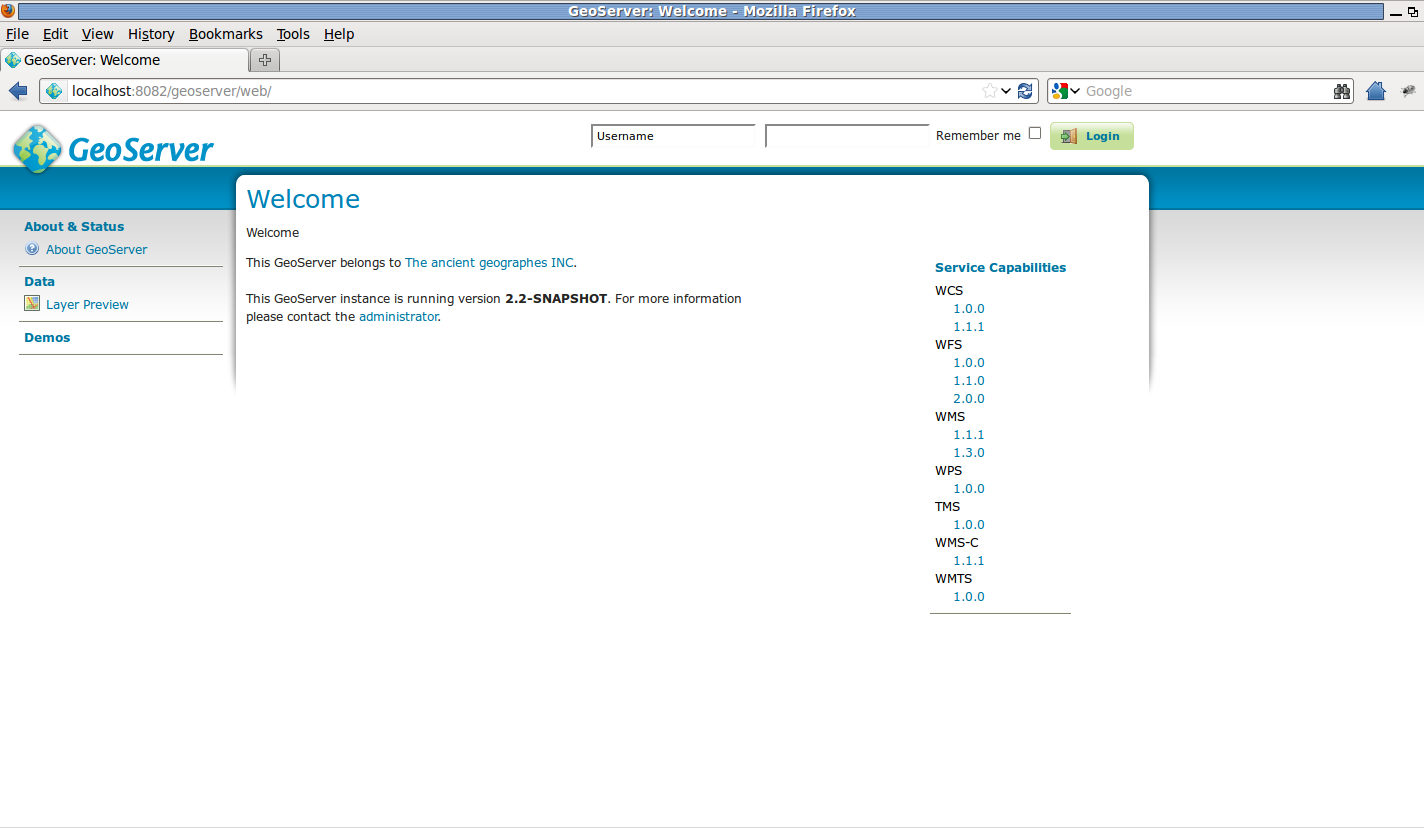
GeoServer trunk running
WPS - Capabilities document
From the Welcome page click on the right pane WPS > 1.0.0 link, which is equivalent to write on the browser the following address:
:file:`http://localhost:8083/geoserver/ows?service=wps&version=1.0.0&request=GetCapabilities`
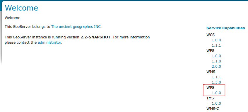
WPS 1.0.0 - GetCapabilities
This is only a trimmed down version of a typical output
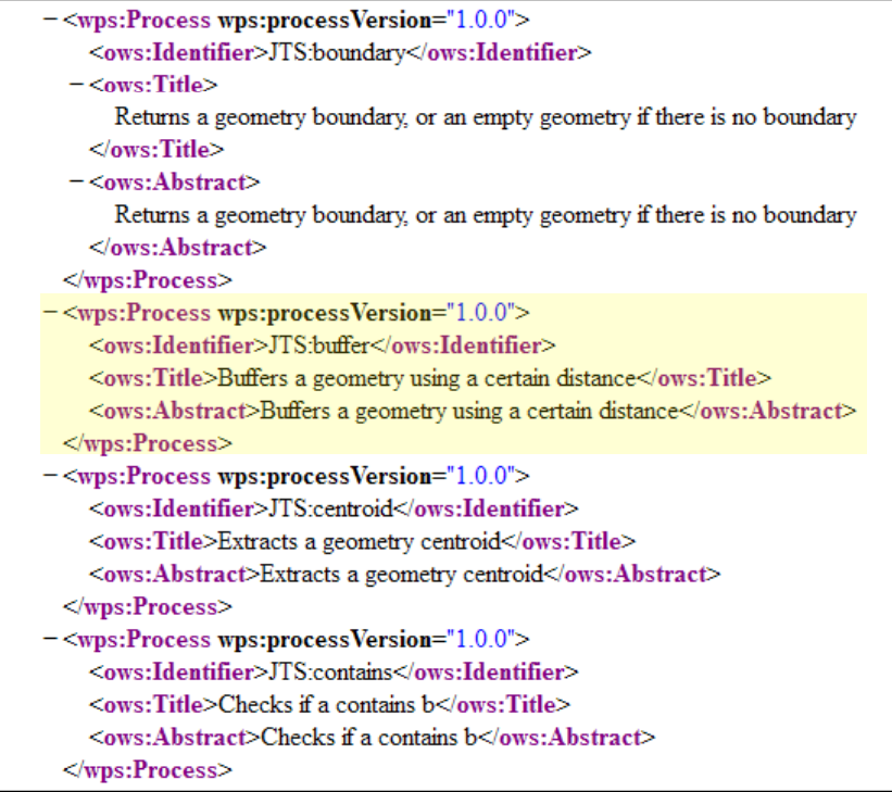
WPS 1.0.0 - GetCapabilities: a section
- The WPS Capabilities document represents:
- Some metadata about the server and its owner
- The list of available processes, with a brief description
WPS - Describe Process
Let’s say we’re interested in the JTS:buffer process.
- Once we have identified the
Process IDwe can issue aDescribe Process Requestto the WPS in order to obtain further details:: http://localhost:8083/geoserver/ows?service=wps&version=1.0.0&request=DescribeProcess&Identifier=JTS:buffer
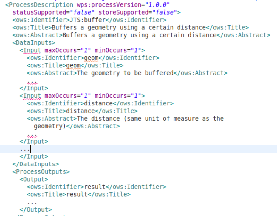
WPS 1.0.0 - DescribeProcess: JTS:buffer
- The WPS Describe Process document gives us:
- The list of Process inputs and outputs
- The IO and parameters descriptions
- A list of accepted formats
- A list of output formats
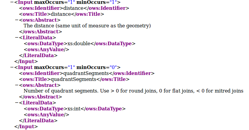
WPS 1.0.0 - DescribeProcess: JTS:buffer - An input parameter accepted formats example
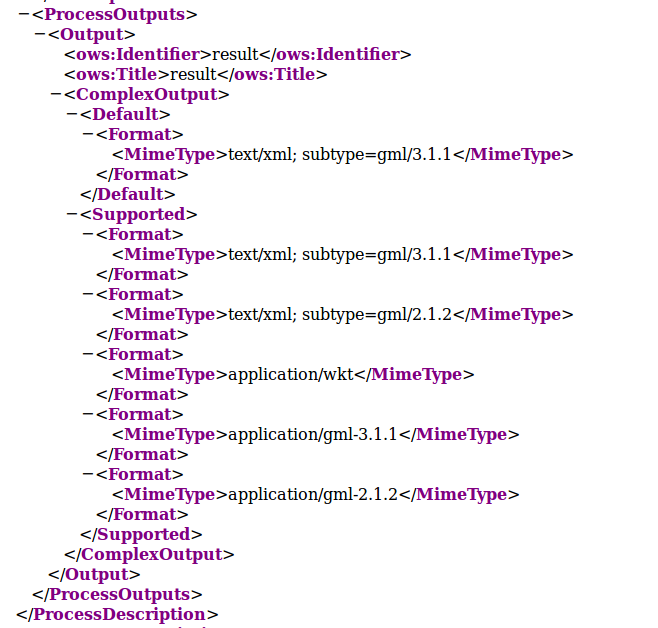
WPS 1.0.0 - DescribeProcess: JTS:buffer - Output parameters example
The IO params can be 1 or more. Each one can be single-valued or multi-valued.
- The Input parameters can be coded as:
Literal,string,numbers,booleansbut also other information can be expressed as simple strings, like a coordinate reference system codeBBOX, a Bounding Box definitionComplex, can be almost anything. They also can be bothtextualorbinary(Base-64). Finally a Complex Input param can beINLINE, specified in the request, orEXTERNAL, is an HTTP GET or POST request.
Note
GeoServer uses only the
mime-typesin order to recognize the parameters type, it is not able to recognize them through theschemayet. Pay attention that also the ComplexEXTERNALHTTP request must specify the correctmime-type.
WPS - Process Execution
In order to issue an Execution we must provide an XML document to the WPS following some rules and schemas.
- We must provide values for each of mandatory Input parameters at least.
- For
complexvalues thesub-typerepresents the output format. - For
inputtypesINLINEvalues different from XML (WKT, plain text, ...) must be included inside[[CDATA]]elements.
Open Firefox and click on
POSTERplugin. In the address bar insert:http://localhost:8083/geoserver/ows?
In the body text-box insert the following XML:
.. code-block:: xml

<?xml version="1.0" encoding="UTF-8"?>
<wps:Execute version="1.0.0" service="WPS" xmlns:xsi="http://www.w3.org/2001/XMLSchema-instance" xmlns="http://www.opengis.net/wps/1.0.0" xmlns:wfs="http://www.opengis.net/wfs" xmlns:wps="http://www.opengis.net/wps/1.0.0" xmlns:ows="http://www.opengis.net/ows/1.1" xmlns:gml="http://www.opengis.net/gml" xmlns:ogc="http://www.opengis.net/ogc" xmlns:wcs="http://www.opengis.net/wcs/1.1.1" xmlns:xlink="http://www.w3.org/1999/xlink" xsi:schemaLocation="http://www.opengis.net/wps/1.0.0 http://schemas.opengis.net/wps/1.0.0/wpsAll.xsd">
  <ows:Identifier>JTS:buffer</ows:Identifier>
  <wps:DataInputs>
    <wps:Input>
      <ows:Identifier>geom</ows:Identifier>
      <wps:Data>
        <wps:ComplexData mimeType="text/xml; subtype=gml/3.1.1">
            <gml:LineString>
                <gml:posList>0.0 0.0 10.0 0.0 10.0 10.0</gml:posList>
            </gml:LineString>
        </wps:ComplexData>
      </wps:Data>
    </wps:Input>
    <wps:Input>
      <ows:Identifier>distance</ows:Identifier>
      <wps:Data>
        <wps:LiteralData>2</wps:LiteralData>
      </wps:Data>
    </wps:Input>
  </wps:DataInputs>
  <wps:ResponseForm>
    <wps:RawDataOutput mimeType="text/xml; subtype=gml/3.1.1">
      <ows:Identifier>result</ows:Identifier>
    </wps:RawDataOutput>
  </wps:ResponseForm>
</wps:Execute>
Click on
POSTbutton. You will get back an XML document ingml/3.1.1representing the buffered geometry:.. code-block:: xml <?xml version="1.0" encoding="UTF-8"?> <gml:Polygon xmlns:sch="http://www.ascc.net/xml/schematron" xmlns:gml="http://www.opengis.net/gml" xmlns:xlink="http://www.w3.org/1999/xlink" srsDimension="2"> <gml:exterior> <gml:LinearRing srsDimension="2"> <gml:posList> 8.0 2.0 8.0 10.0 8.03842943919354 10.390180644032258 8.152240934977426 10.76536686473018 8.33706077539491 11.111140466039204 8.585786437626904 11.414213562373096 8.888859533960796 11.66293922460509 9.23463313526982 11.847759065022574 9.609819355967744 11.96157056080646 10.0 12.0 10.390180644032256 11.96157056080646 10.76536686473018 11.847759065022574 11.111140466039204 11.66293922460509 11.414213562373096 11.414213562373096 11.66293922460509 11.111140466039204 11.847759065022574 10.76536686473018 11.96157056080646 10.390180644032256 12.0 10.0 12.0 0.0 11.96157056080646 -0.3901806440322565 11.847759065022574 -0.7653668647301796 11.66293922460509 -1.1111404660392044 11.414213562373096 -1.414213562373095 11.111140466039204 -1.6629392246050905 10.76536686473018 -1.8477590650225735 10.390180644032256 -1.9615705608064609 10.0 -2.0 0.0 -2.0 -0.39018064403225733 -1.9615705608064606 -0.7653668647301807 -1.847759065022573 -1.1111404660392044 -1.6629392246050905 -1.4142135623730954 -1.414213562373095 -1.662939224605091 -1.111140466039204 -1.8477590650225737 -0.7653668647301793 -1.9615705608064609 -0.3901806440322567 -2.0 2.4492935982947064E-16 -1.9615705608064609 0.3901806440322572 -1.8477590650225735 0.7653668647301798 -1.6629392246050907 1.1111404660392044 -1.414213562373095 1.4142135623730951 -1.111140466039204 1.6629392246050907 -0.7653668647301786 1.847759065022574 -0.3901806440322551 1.961570560806461 0.0 2.0 8.0 2.0 </gml:posList> </gml:LinearRing> </gml:exterior> </gml:Polygon>
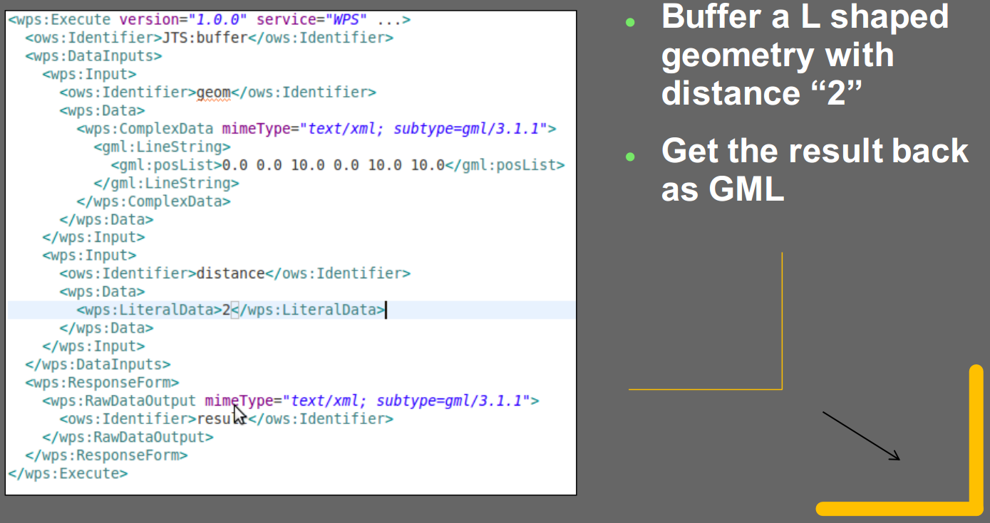
WPS 1.0.0 - ExecuteProcess: JTS:buffer - Example
Warning
The output of an Execute can be of two types:
RAW, which streams back directly the output, XML or Binary (Base-64), but for only one of the output values.RawDataOutputcannot be used for multiple outputs.DOCUMENT, that creates an output XML Document containing N-Blocks, each one corresponding to one output param. If the outputs are binary, they will be encoded Base-64 into the respective XML block of the document.