
Getting tiles
The OGC-API Tiles allows getting tiles through paths identifying the collection and tile coordinates within a Tile Matrix Set.
Raster tiles
This page
provides URL templates to get map tiles for nurc:Img_Sample layer on WebMercatorQuad Tile Matrix Set in the available formats.
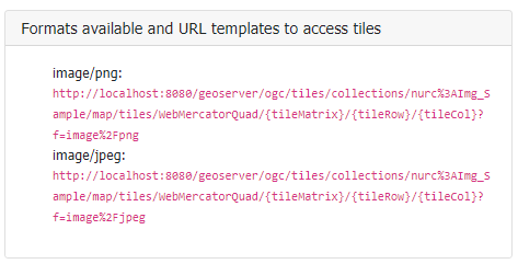
Filling the URL template with proper tileMatrix id, tileRow and tileCol values (within the Tile Matrix Set Limits) provides the specified map tile.
For example this request:
http://localhost:8083/geoserver/ogc/tiles/v1/collections/nurc%3AImg_Sample/map/tiles/WebMercatorQuad/4/6/4?f=image%2Fpng
will result in getting the following tile:
Vector tiles
This page provides available tiles for the specified vector collection.
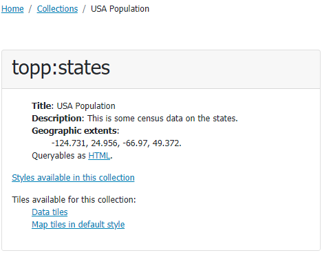
Depending on the available tile formats being previously configured, it is possible to get tiles in different ways:
- Vector data being provided as is, as vector
Data tiles. - Vector data being provided as styled
Map tiles(raster tiles).
Map tiles
Getting Map tiles results in requesting tiles in a raster output format (i.e. PNG, JPEG,...) as seen in the previous section.
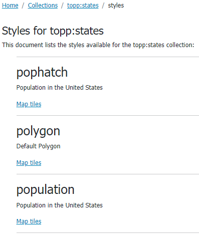
The “Map tiles in default style” link allows to get vector data provided as map tiles using the default style.
In case the tile collection supports multiple alternate style, it is possible to get different map tiles (based on different styles).
This page provides the set of alternate styles available for the topp:states tiled collection and the related map tiles resources.
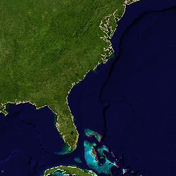
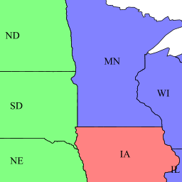
Selecting a specific map tile (i.e. from population) and a specific tile matrix set (i.e. WebMercatorQuad) results in this:
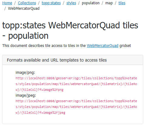
Where you can notice the population style in the template URLs. Tiles obtained with that URL template are the result of the population style being applied.
http://localhost:8083/geoserver/ogc/tiles/v1/
collections/topp%3Astates/styles/population/map/
tiles/WebMercatorQuad/5/11/7?f=image%2Fpng
will result in the following tile:
Data tiles
Getting Data tiles results in a vector format. Depending on the requested output format (i.e. application/vnd.mapbox-vector-tile), it may require a client supporting it for further visualization.
http://localhost:8083/geoserver/ogc/tiles/v1/
collections/topp%3Astates/
tiles/WebMercatorQuad/5/11/7?f=application%2Fjson%3Btype%3Dgeojson
will result in getting the following GeoJSON tile content (geometry coordinates have been omitted for brevity):
{
   "type":"FeatureCollection",
   "totalFeatures":"unknown",
   "features":[
          {
                 "type":"Feature",
                 "id":"states.1",
                 "geometry":{
                        "type":"Polygon"
                 },
                 "geometry_name":"the_geom",
                 "properties":{
                        "CARPOOL":652603,
                        "DRVALONE":3741715,
                        "EMPLOYED":5417967,
                        "FAMILIES":2924880,
                        "FEMALE":5878369,
                        "HOUSHOLD":4202240,
                        "LAND_KM":143986.61,
                        "MALE":5552233,
                        "MANUAL":828906,
                        "PERSONS":1.1430602E7,
                        "PUBTRANS":538071,
                        "P_FEMALE":0.514,
                        "P_MALE":0.486,
                        "SAMP_POP":1747776,
                        "SERVICE":1360159,
                        "STATE_ABBR":"IL",
                        "STATE_FIPS":"17",
                        "STATE_NAME":"Illinois",
                        "SUB_REGION":"E N Cen",
                        "UNEMPLOY":385040,
                        "WATER_KM":1993.335,
                        "WORKERS":4199206
                 }
          },
          {
                 "type":"Feature",
                 "id":"states.10",
                 "geometry":{
                        "type":"Polygon"
                 },
                 "geometry_name":"the_geom",
                 "properties":{
                        "CARPOOL":312042,
                        "DRVALONE":1816079,
                        "EMPLOYED":2367395,
                        "FAMILIES":1368334,
                        "FEMALE":2652758,
                        "HOUSHOLD":1961206,
                        "LAND_KM":178445.951,
                        "MALE":2464315,
                        "MANUAL":386746,
                        "PERSONS":5117073,
                        "PUBTRANS":47129,
                        "P_FEMALE":0.518,
                        "P_MALE":0.482,
                        "SAMP_POP":864999,
                        "SERVICE":659782,
                        "STATE_ABBR":"MO",
                        "STATE_FIPS":"29",
                        "STATE_NAME":"Missouri",
                        "SUB_REGION":"W N Cen",
                        "UNEMPLOY":155388,
                        "WATER_KM":2100.115,
                        "WORKERS":1861192
                }
        }
        ]
}